IMAGES TAKEN NEAR TO
Fearnleigh Drive, NOTTINGHAM, NG6 0JH
Introduction
This page details the photographs taken nearby to Fearnleigh Drive, NG6 0JH by members of the Geograph project.
The Geograph project started in 2005 with the aim of publishing, organising and preserving representative images for every square kilometre of Great Britain, Ireland and the Isle of Man.

There are currently over 7.5m images from over14,400 individuals and you can help contribute to the project by visiting https://www.geograph.org.uk
Image Map (Loading...)


Getting Data...Please wait
Leaflet Map data © OpenStreetMap
Images are licensed for reuse under creativecommons.org/licenses/by-sa/2.0
Notes
- Clicking on the map will re-center to the selected point.
- The higher the marker number, the further away the image location is from the centre of the postcode.
Image Listing (55 Images Found)
Images are licensed for reuse under creativecommons.org/licenses/by-sa/2.0
Image
Details
Distance
1
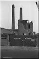
W E Saxby (Nottingham) Ltd, Bar Lane, Nottingham
Firm of bleachers and dyers. Closure announced 9-12-1983. Works in course of demolition. Two fine square (Staffordshire style) chimneys.
Image: © Chris Allen
Taken: 29 Sep 1985
0.03 miles
2
Ellis Guilford School
located on Bar Lane, Nottingham. It is also home to the Nottingham School of Music
Image: © Tom Courtney
Taken: 9 Sep 2005
0.07 miles
3
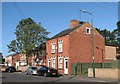
Basford Road: new and old
Lineker's Cottages date from 1879, the houses to the left from more recent years.
Image: © John Sutton
Taken: 13 Sep 2011
0.09 miles
4

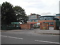
Nottingham - NG6 (Basford)
Looking outwards towards the entrance/exit of the Bar Lane Industrial Park on Bar Lane, Basford. The premises are a mix of single and two storey buildings and the businesses seem to be a mixture of small manufacturing/industrial enterprises balanced with 'light industrial' units. A single-storey former hosiery factory overlooking Murphy's Brewery on Alpine Street is however, in a derelict state.
Image: © David Hallam-Jones
Taken: 4 May 2012
0.15 miles
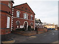
5
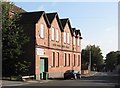
Basford Road: former Sunday School
The original name of this building, Baptist Centenary Sunday Schools, shows clearly in the low sunlight of a September morning. The building is now occupied by Sherwood Fabrics. It dates from 1899. For another view, see Image
Image: © John Sutton
Taken: 13 Sep 2011
0.15 miles
6

Former brewery, Alpine Street, Old Basford
Former Hutchinson's Prince of Wales Brewery site, now occupied by Murphy and Sons, 'supplier of processing aids and additives to the brewing and food industries' http://www.murphyandson.co.uk/heritage/index.html
Image: © Tim Heaton
Taken: 11 Nov 2012
0.16 miles
7
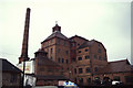
The rear of the former Prince of Wales Brewery
Picture taken stood on a garden wall above a 10 foot drop. A very fine example of a tower brewery.
Image: © Chris Allen
Taken: 24 Nov 1990
0.16 miles
8
Nottingham - Basford NG6
Basford Road hosted two churches in times past. Basford Road Baptist Church - in the centre of this picture - was opened in 1867 and is still functioning although the Sunday School premises to its left now operates as a base for a commercial business, as does the ex-Barley Mow pub on the right of it. In addition and further down the hill towards Church street lies a now defunct Congregational Church.
Image: © David Hallam-Jones
Taken: 1 Apr 2012
0.16 miles
9
Nottingham - NG6 (Basford)
The entrance to the Bar Lane Industrial Park at the Percy Street end of Bar Lane, Basford. Small to medium size manufacturers are its main tenants although a well-known tennis coaching organisation was using one of the warehouse buildings (on a temporary basis?) up until 2011.
Image: © David Hallam-Jones
Taken: 4 May 2012
0.17 miles
10
Basford Road: Baptist chapel and former pub
In the centre is the General Baptist Chapel of 1867. To the left is the Sunday School (1899), now Sherwood Fabrics, and to the right the offices of Micro Mesh, originally a Home Brewery tied house, The Barley Mow. For a close-up, see Image
Image: © John Sutton
Taken: 13 Sep 2011
0.17 miles