IMAGES TAKEN NEAR TO
Whitemoor Road, NOTTINGHAM, NG6 0HJ
Introduction
This page details the photographs taken nearby to Whitemoor Road, NG6 0HJ by members of the Geograph project.
The Geograph project started in 2005 with the aim of publishing, organising and preserving representative images for every square kilometre of Great Britain, Ireland and the Isle of Man.

There are currently over 7.5m images from over14,400 individuals and you can help contribute to the project by visiting https://www.geograph.org.uk
Image Map
Images are licensed for reuse under creativecommons.org/licenses/by-sa/2.0
Notes
- Clicking on the map will re-center to the selected point.
- The higher the marker number, the further away the image location is from the centre of the postcode.
Image Listing (167 Images Found)
Images are licensed for reuse under creativecommons.org/licenses/by-sa/2.0
Image
Details
Distance
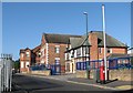
6
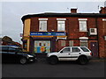
Offices of Micro Mesh
There is a small factory building behind the offices. I'd be very surprised if this building were not originally a Home Ales pub.
The baptist church next door is still in use as such.
Image: © David Lally
Taken: 30 Dec 2009
0.05 miles
7
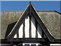
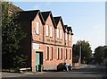
Basford Road: bargeboards of the former Barley Mow
This building is now the offices of Micro Mesh - see Image It was originally a Home Brewery Company tied house, the Barley Mow, one of many the company built in this mock-Tudor style. The wood is nicely carved with hops and barley and the building's date and ownership appear on the cross beam: "HBC 1936". For another view, see David Lally's Image
Image: © John Sutton
Taken: 13 Sep 2011
0.05 miles
8
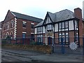
Basford Road: Baptist chapel and former pub
In the centre is the General Baptist Chapel of 1867. To the left is the Sunday School (1899), now Sherwood Fabrics, and to the right the offices of Micro Mesh, originally a Home Brewery tied house, The Barley Mow. For a close-up, see Image
Image: © John Sutton
Taken: 13 Sep 2011
0.05 miles
9
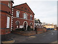
Nottingham - Basford NG6
Basford Road hosted two churches in times past. Basford Road Baptist Church - in the centre of this picture - was opened in 1867 and is still functioning although the Sunday School premises to its left now operates as a base for a commercial business, as does the ex-Barley Mow pub on the right of it. In addition and further down the hill towards Church street lies a now defunct Congregational Church.
Image: © David Hallam-Jones
Taken: 1 Apr 2012
0.06 miles
10
Basford Road: former Sunday School
The original name of this building, Baptist Centenary Sunday Schools, shows clearly in the low sunlight of a September morning. The building is now occupied by Sherwood Fabrics. It dates from 1899. For another view, see Image
Image: © John Sutton
Taken: 13 Sep 2011
0.06 miles