IMAGES TAKEN NEAR TO
Nursery Lane, NOTTINGHAM, NG6 0EG
Introduction
This page details the photographs taken nearby to Nursery Lane, NG6 0EG by members of the Geograph project.
The Geograph project started in 2005 with the aim of publishing, organising and preserving representative images for every square kilometre of Great Britain, Ireland and the Isle of Man.

There are currently over 7.5m images from over14,400 individuals and you can help contribute to the project by visiting https://www.geograph.org.uk
Image Map
Images are licensed for reuse under creativecommons.org/licenses/by-sa/2.0
Notes
- Clicking on the map will re-center to the selected point.
- The higher the marker number, the further away the image location is from the centre of the postcode.
Image Listing (36 Images Found)
Images are licensed for reuse under creativecommons.org/licenses/by-sa/2.0
Image
Details
Distance
1
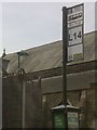
UK Bus Stop Sign
UK Bus Stop Sign on Nursery Lane, Nottingham Nottinghamshire.
Image: © gary
Taken: 7 Jun 2016
0.06 miles
2
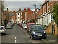
Wallis Street, Basford
Classic turn of the century (c.1900) Nottingham with 2 and 3 storey red brick terraced houses.
Image: © Alan Murray-Rust
Taken: 22 Feb 2022
0.06 miles
3
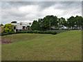
Arnold Road: where Derby trains once crossed
This grassy knoll, in a children's play area, is on the reclaimed and landscaped site of Bagthorpe West Curve, which led Great Northern Derby-bound trains from Bagthorpe Junction to Basford North, then west through Kimberley and Ilkeston. Carriage sidings, where spare coaches were stabled, were to the right and behind the camera and the Great Central main line from Nottingham Victoria to Sheffield and Manchester a little further to the right. The GNR's lattice bridge across Arnold Road (which is behind the line of bushes) was where the trees in the centre are, and beyond it the line curved to the left behind where the industrial unit now stands to Basford East Junction, subject of Ben Brooksbank's Image
Image: © John Sutton
Taken: 21 Jun 2011
0.07 miles
5
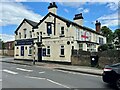
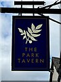
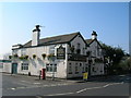
The Park Tavern
On the corner of Arnold and Warlock roads.
See also Image
Image: © David Lally
Taken: 10 Jul 2024
0.08 miles
8
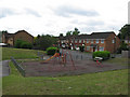
Arnold Road: play area on old railway land
This landscaped area and children's playground, serving the houses on Roman Drive, Gothic Close and Script Drive, is built on land once occupied by the Great Northern Nottingham to Derby Friargate railway, which crossed Arnold Road behind the camera. The street names recall the Barlock Typewriter Company, whose factory was on - and gave its name to - nearby Barlock Road.
Image: © John Sutton
Taken: 21 Jun 2011
0.10 miles
9

East from Park Lane bridge
This view eastwards from Park Lane bridge shows how the course of the former Great Northern Railway line from Nottingham to Derby Friargate has been obliterated since it closed in 1968. Ben Brooksbank's Image] shows what the lines east of here looked like in the days of steam; the position of the engine in that picture was just beyond the houses straight ahead.
Image: © John Sutton
Taken: 6 May 2011
0.10 miles
10
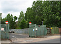
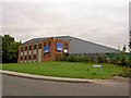
Arnold Road: where the Great Central was
The line of trees marks the former course of the Great Central main line from Nottingham Victoria to Sheffield and Manchester, which crossed Arnold Road on a bridge just to the right. This was a good spot for trainspotting, with traffic on the GC and also the GN Derby Friargate line. Derby-bound trains took the Bagthorpe West Curve, which crossed Arnold Road a little way down the hill to the left (see Image]); when the smoke of those from Derby was spotted away to the left, beyond the sidings where the depot behind these railings is, there was a frantic dash under the GC bridge to the right to see them emerge from the short "Rathole" tunnel which had brought them under the GN Back Line to Daybrook and Colwick and the GC - they then passed under Arnold Road on their way along the single-track Bagthorpe East Curve, whose route is echoed by the northern end of Fenton Road, which was built after the railway was closed and its cuttings and embankments filled or levelled, landscaped or built on.
Image: © John Sutton
Taken: 21 Jun 2011
0.10 miles