IMAGES TAKEN NEAR TO
Oakleigh Street, NOTTINGHAM, NG6 0DQ
Introduction
This page details the photographs taken nearby to Oakleigh Street, NG6 0DQ by members of the Geograph project.
The Geograph project started in 2005 with the aim of publishing, organising and preserving representative images for every square kilometre of Great Britain, Ireland and the Isle of Man.

There are currently over 7.5m images from over14,400 individuals and you can help contribute to the project by visiting https://www.geograph.org.uk
Image Map
Images are licensed for reuse under creativecommons.org/licenses/by-sa/2.0
Notes
- Clicking on the map will re-center to the selected point.
- The higher the marker number, the further away the image location is from the centre of the postcode.
Image Listing (61 Images Found)
Images are licensed for reuse under creativecommons.org/licenses/by-sa/2.0
Image
Details
Distance
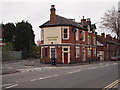
1
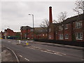
Nottingham - NG6 (Highbury Vale)
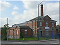
A defunct public baths sits on Vernon Road at the junction with Oakleigh Street. These were opened in 1908 and records show that 10,000 bathers attended one year, including 1,000 school children who attended for swimming lessons, whilst nearly 6,000 individuals patronised the ordinary baths. It is currently home to a Christian church congregation.
Image: © David Hallam-Jones
Taken: 4 May 2012
0.02 miles
2
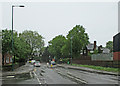
Basford: the site of Northern Bridge
The houses on the left and the industrial estate on the right are built on the site of the Great Northern Railway line from Nottingham to Derby Friargate, which crossed the road here on a substantial brick arch. Basford North (originally Basford & Bulwell) Station was to the right, its platforms ending at the bridge, high above Vernon Road. The high embankment to the left was levelled and Oakleigh Street, Susan Drive, Gabrielle Close and Lauriston Drive occupy its site.
Image: © John Sutton
Taken: 18 May 2015
0.03 miles
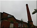
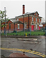
5
Former Northern Baths
After lying empty for many years, it is currently home to and evangelical church.
Image: © Alan Murray-Rust
Taken: 27 Aug 2009
0.04 miles
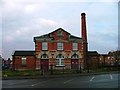
6
The former Northern Baths
The building is now used by the Calvary Family Church. It was photographed from the corner of Vernon Road and Roderick Street on a wet morning.
Image: © John Sutton
Taken: 18 May 2015
0.04 miles
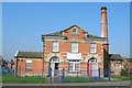
7
Former Municipal Swimming Baths, Northern Baths, Vernon Road
Currently the subject of an enforcement notice "without planning permission the change of use of the Land from leisure (municipal swimming baths) to production of videos and DVDs and storage and distribution of these and other goods." An appeal is in progress.
Image: © Mick Garratt
Taken: 20 Feb 2006
0.05 miles
8
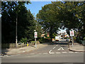
Saxondale Drive
Residential road off Highbury Road.
Image: © Alan Murray-Rust
Taken: 27 Aug 2009
0.07 miles
9
Nottingham - NG6 (Vernon Road)
This unusually named pub - Catchems Corner (sometimes spelt Catchem's Corner) - sits at the apex of a triangle created by the convergence of Vernon Road and Bulwell Lane. The latter is on its left when viewed from this position. Both of these roads connect with Southwark Street in Basford.
Image: © David Hallam-Jones
Taken: 4 May 2012
0.08 miles
10
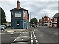
Catchams Corner
The lack of an apostrophe dates back to at lease 2008 - the date of true earliest Google Street View image.
Image: © David Lally
Taken: 28 Jul 2023
0.08 miles