IMAGES TAKEN NEAR TO
Shardale Gardens, NOTTINGHAM, NG6 0BW
Introduction
This page details the photographs taken nearby to Shardale Gardens, NG6 0BW by members of the Geograph project.
The Geograph project started in 2005 with the aim of publishing, organising and preserving representative images for every square kilometre of Great Britain, Ireland and the Isle of Man.

There are currently over 7.5m images from over14,400 individuals and you can help contribute to the project by visiting https://www.geograph.org.uk
Image Map (Loading...)


Getting Data...Please wait
Leaflet Map data © OpenStreetMap
Images are licensed for reuse under creativecommons.org/licenses/by-sa/2.0
Notes
- Clicking on the map will re-center to the selected point.
- The higher the marker number, the further away the image location is from the centre of the postcode.
Image Listing (75 Images Found)
Images are licensed for reuse under creativecommons.org/licenses/by-sa/2.0
Image
Details
Distance
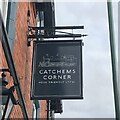
1
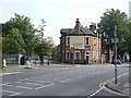
Catchems Corner
An instance where pub renaming has become more rather than less traditional. This was originally the Station Hotel, but the location was always known as Catchems Corner, for reasons which I have been unable to discover. One possibility is that it was the location of a toll gate.
Image: © Alan Murray-Rust
Taken: 27 Aug 2009
0.03 miles
2
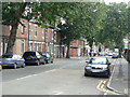
Vernon Road
This is the main road from Nottingham to Bulwell.
Image: © Alan Murray-Rust
Taken: 27 Aug 2009
0.04 miles
3
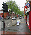
A wet morning in Vernon Road
Looking towards Old Basford and the city from outside the Post Office store on the corner of Mandalay Street.
Image: © John Sutton
Taken: 18 May 2015
0.06 miles
6
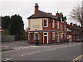
Nottingham - NG6 (Vernon Road)
This unusually named pub - Catchems Corner (sometimes spelt Catchem's Corner) - sits at the apex of a triangle created by the convergence of Vernon Road and Bulwell Lane. The latter is on its left when viewed from this position. Both of these roads connect with Southwark Street in Basford.
Image: © David Hallam-Jones
Taken: 4 May 2012
0.06 miles
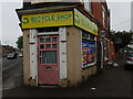
7
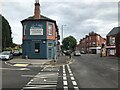
Catchams Corner
The lack of an apostrophe dates back to at lease 2008 - the date of true earliest Google Street View image.
Image: © David Lally
Taken: 28 Jul 2023
0.06 miles
8
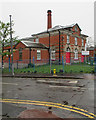
The former Northern Baths
The building is now used by the Calvary Family Church. It was photographed from the corner of Vernon Road and Roderick Street on a wet morning.
Image: © John Sutton
Taken: 18 May 2015
0.10 miles
9
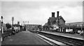
Basford North (former Basford & Bulwell) Station
View eastward, towards Nottingham (Victoria), Colwick etc. and Grantham. Basford & Bulwell station only became 'Basford North' on 21/9/53; it was closed on 7/9/64 to passengers, along with the service from Derby (Friargate) etc. (goods 4/9/67). Beyond the station can be seen Park Lane Bridge, beyond which was the bridge carrying the main ex-Great Central line from Sheffield (Victoria) to Nottingham and the South. Trains through this station to/from Nottingham Victoria joined the main line at Bagthorpe Junction by connections either side of this bridge. A curve to the left just beyond the end of the Up (left) platform connected at Bulwell South Junction with the main line towards Sheffield. The lines straight ahead led to Leen Valley Junction and by the Daybrook Loop ('Back Line') round the north side of Nottingham to the great Colwick Yards and the main line to Grantham; the Back Line lost its meagre passenger services after the partial collapse of Mapperley Tunnel on 4/4/60, although Goods continued until 1/6/64. The GC main line effectively ceased as a through route on 5/9/66 and Nottingham Victoria closed on 5/7/67.
Image: © Ben Brooksbank
Taken: 21 Aug 1963
0.10 miles
10
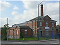
Former Northern Baths
After lying empty for many years, it is currently home to and evangelical church.
Image: © Alan Murray-Rust
Taken: 27 Aug 2009
0.10 miles