IMAGES TAKEN NEAR TO
Nottingham Road, NOTTINGHAM, NG6 0BU
Introduction
This page details the photographs taken nearby to Nottingham Road, NG6 0BU by members of the Geograph project.
The Geograph project started in 2005 with the aim of publishing, organising and preserving representative images for every square kilometre of Great Britain, Ireland and the Isle of Man.

There are currently over 7.5m images from over14,400 individuals and you can help contribute to the project by visiting https://www.geograph.org.uk
Image Map
Images are licensed for reuse under creativecommons.org/licenses/by-sa/2.0
Notes
- Clicking on the map will re-center to the selected point.
- The higher the marker number, the further away the image location is from the centre of the postcode.
Image Listing (240 Images Found)
Images are licensed for reuse under creativecommons.org/licenses/by-sa/2.0
Image
Details
Distance
2
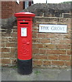
Edward VII postbox on Fox Grove, Basford
Postbox No. NG6 193.
See Image] for context.
Image: © JThomas
Taken: 27 Mar 2017
0.02 miles
3
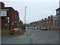
Nottingham Road, Basford
Showing position of Postbox No. NG6 193.
See Image] for postbox.
Image: © JThomas
Taken: 27 Mar 2017
0.02 miles
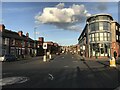
4
Fox Grove
Typical terraced street in Basford. The pillar box is an Edward VII version http://www.geograph.org.uk/photo/4122825 .
Image: © Alan Murray-Rust
Taken: 14 Aug 2014
0.03 miles
5
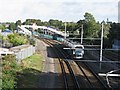
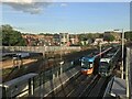
Southbound tram leaving Basford
This view from Church Street bridge shows the two tramway tracks, laid on what was once part of the goods yard of Basford Vernon railway station, and on the right the double track of the Nottingham-Mansfield-Worksop railway. The railway station, which closed in the early 1960s, was this side of the new bridge which spans all four tracks. There were once goods sidings to the left of the grey security fence; that part of the goods yard is now in commercial use.
Image: © John Sutton
Taken: 13 Sep 2011
0.03 miles
6
Railway and tramway north of Church Street, Basford
The Nottingham Express Transit tramway (left, with overhead electrification equipment) and the railway towards Mansfield and Worksop, as seen from the Church Street road bridge in Basford. The enormous footbridge in the distance links Vernon Road (out of view to the right) with Basford tram stop, a platform of which can just be discerned under the footbridge.
Image: © Richard Vince
Taken: 9 Jun 2012
0.04 miles
8

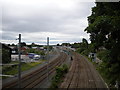
Railway and tramway at Basford
The two tracks in the foreground are the Nottingham-Mansfield-Worksop Robin Hood Line, originally built by the Midland Railway in 1848, the two beyond the green railings the NET tramway. A southbound tram has just left Basford tram stop (behind the camera - see Image]). The Mansfield stone bridge, which dates from the 1870s (it replaced a level crossing), carries Church Street over the railway, the tramway and the River Leen. Beyond it, a newer (1930s) bridge carries Western Boulevard, the ring road. The dark wooden building on the right is the former railway goods warehouse; what was the railway goods yard is now a small industrial estate. For a view from the other side of Church Street Bridge, see Image
Image: © John Sutton
Taken: 21 Jun 2011
0.04 miles
9

Basford Tram Stop
North of Basford the NET trams run parallel to the Robin Hood Line railway (the double track in the foreground) as far as Hucknall. The red-and-cream lattice footbridge over the railway at David Lane crossing is visible in the distance. Before the withdrawal of the steam-operated Nottingham-Mansfield-Worksop passenger trains in 1964, this was the site of Basford Vernon railway station.
Image: © John Sutton
Taken: 21 Jun 2011
0.05 miles
10
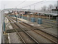
Basford Vernon railway station (site), and Basford tram stop, Nottingham
Opened in 1848 on the two furthest lines by the Midland Railway, on what is now the line from Nottingham to Worksop, this station closed in 1967. No trace apparently remains. It acquired the suffix 'Vernon' in 1952.
View north west towards Old Basford and Worksop. The railway line reopened as the Robin Hood Line in 1993 but Basford was not one of the reopened stations. However, the tram lines and tram stop in the foreground were opened in 2004, on the site of the former goods shed.
Image: © Nigel Thompson
Taken: 11 Jan 2016
0.05 miles