IMAGES TAKEN NEAR TO
Buxton Close, NOTTINGHAM, NG5 9RN
Introduction
This page details the photographs taken nearby to Buxton Close, NG5 9RN by members of the Geograph project.
The Geograph project started in 2005 with the aim of publishing, organising and preserving representative images for every square kilometre of Great Britain, Ireland and the Isle of Man.

There are currently over 7.5m images from over14,400 individuals and you can help contribute to the project by visiting https://www.geograph.org.uk
Image Map
Images are licensed for reuse under creativecommons.org/licenses/by-sa/2.0
Notes
- Clicking on the map will re-center to the selected point.
- The higher the marker number, the further away the image location is from the centre of the postcode.
Image Listing (8 Images Found)
Images are licensed for reuse under creativecommons.org/licenses/by-sa/2.0
Image
Details
Distance
1
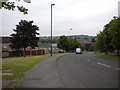
Horsham Drive, Top Valley
Seen from Old Farm Road, with the southern end of Knights Close visible on the right.
Image: © Richard Vince
Taken: 11 Jun 2013
0.16 miles
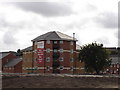
2
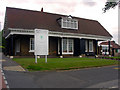
Bulwell Forest Club House
Bulwell Forest Golf Club est 1902
Image: © Q
Taken: 14 Jun 2005
0.17 miles
3
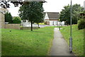
Footpath in Top Valley
One of the principal pedestrian routes through the estate, where pedestrian and vehicle routes are largely separated.
pede
Image: © Alan Murray-Rust
Taken: 20 Jul 2010
0.17 miles
4
South end of Old Farm Road, Top Valley
Image: © Richard Vince
Taken: 11 Jun 2013
0.18 miles
5
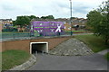
Purple patch
A bus in garish advertising livery passes over a subway on Old Farm Road
Image: © Alan Murray-Rust
Taken: 20 Jul 2010
0.22 miles
6
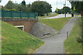
Subway access
At the roundabout at the junction of Top Valley Drive and Old Farm Road.
Image: © Alan Murray-Rust
Taken: 20 Jul 2010
0.23 miles
8
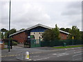
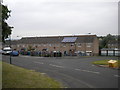
North Nottingham e-Learning Centre, Top Valley Drive
Image: © Oxymoron
Taken: 4 Sep 2008
0.24 miles