IMAGES TAKEN NEAR TO
Muirfield Road, NOTTINGHAM, NG5 9QR
Introduction
This page details the photographs taken nearby to Muirfield Road, NG5 9QR by members of the Geograph project.
The Geograph project started in 2005 with the aim of publishing, organising and preserving representative images for every square kilometre of Great Britain, Ireland and the Isle of Man.

There are currently over 7.5m images from over14,400 individuals and you can help contribute to the project by visiting https://www.geograph.org.uk
Image Map
Images are licensed for reuse under creativecommons.org/licenses/by-sa/2.0
Notes
- Clicking on the map will re-center to the selected point.
- The higher the marker number, the further away the image location is from the centre of the postcode.
Image Listing (30 Images Found)
Images are licensed for reuse under creativecommons.org/licenses/by-sa/2.0
Image
Details
Distance
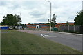
1
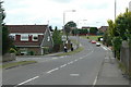
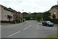
Muirfield Road
The eastern end, from Bewcastle road. One of the main distributor roads through the development.
Image: © Alan Murray-Rust
Taken: 20 Jul 2010
0.03 miles
2
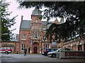
Bestwood Lodge Hotel
Former and last royal hunting Lodge (now used as a hotel) of the Bestwood St. Albans estate, former royal hunting park now used as Bestwood Country Park.
Image: © Q
Taken: 15 Jun 2005
0.08 miles
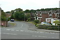
3
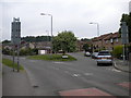
Former bus turning circle, Warren Hill
This turning circle, built into the junction of Finsbury Road with Bewcastle Road (foreground), did not have a particularly long life as a bus terminus: for most of its history, this area of housing has been served by buses either by way of a one way loop, or on their way from one place to another. Nowadays its primary use is for car parking.
Image: © Richard Vince
Taken: 11 Jun 2013
0.11 miles
4
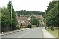
Bewcastle Road
Looking north west at Emmanuel Avenue.
Image: © Alan Murray-Rust
Taken: 20 Jul 2010
0.13 miles
5
Big Wood School
Comprehensive Secondary school built in the 1980s as part of the final stage of the Top Valley development.
Image: © Alan Murray-Rust
Taken: 20 Jul 2010
0.13 miles
6
Grampian Drive
Off Bewcastle Road; it leads to a group of roads with names of British mountain ranges.
Image: © Alan Murray-Rust
Taken: 20 Jul 2010
0.14 miles
7
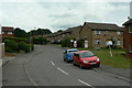
Lambeth Road
Part of the final stage of development of Top Valley. Originally planned as council housing, it was finally developed as private housing, under the name Warren Hill.
Image: © Alan Murray-Rust
Taken: 20 Jul 2010
0.15 miles
8
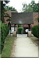
Lych gate, Emmanuel Church
On another website a 'Local parishioner' writes:
"The lychgate has recently (2009) been relocated to the other side of the church yard. This was done in order that it might be saved from destruction through repeated acts of vandalism. The stone walls remain in position but the steps have recently been covered over by a ramp. The relocated wooden structure has been resited on new stone work. The original location had been the main entrance into the church yard but had fallen into disuse due to modern housing developments surrounding the church. The new location means that the lychgate functions once again as it was intended.
I believe that English heritage have lost interest in it being a listed structure now that it has been moved."
The gates mentioned in the English Heritage listing are missing.
Image: © Alan Murray-Rust
Taken: 20 Jul 2010
0.15 miles
9
Finsbury Road
Part of the final stage of development of Top Valley. Originally planned as council housing, it was finally developed as private housing, under the name Warren Hill.
Off Bewcastle Road.
Image: © Alan Murray-Rust
Taken: 20 Jul 2010
0.15 miles
10
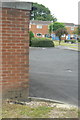
Bench mark, Bewcastle Road
Better seen in the high resolution version. Cut into the end wall of the group of garages seen in http://www.geograph.org.uk/photo/2004955 .
Image: © Alan Murray-Rust
Taken: 20 Jul 2010
0.16 miles