IMAGES TAKEN NEAR TO
Jarrow Gardens, NOTTINGHAM, NG5 9PH
Introduction
This page details the photographs taken nearby to Jarrow Gardens, NG5 9PH by members of the Geograph project.
The Geograph project started in 2005 with the aim of publishing, organising and preserving representative images for every square kilometre of Great Britain, Ireland and the Isle of Man.

There are currently over 7.5m images from over14,400 individuals and you can help contribute to the project by visiting https://www.geograph.org.uk
Image Map
Images are licensed for reuse under creativecommons.org/licenses/by-sa/2.0
Notes
- Clicking on the map will re-center to the selected point.
- The higher the marker number, the further away the image location is from the centre of the postcode.
Image Listing (25 Images Found)
Images are licensed for reuse under creativecommons.org/licenses/by-sa/2.0
Image
Details
Distance
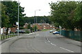
1
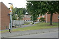
Northern names
Vehicle access to several of the closes off Bewcastle Road. As can be seen, the names all have associations with the north east of England.
Image: © Alan Murray-Rust
Taken: 20 Jul 2010
0.04 miles
2
Cuillin Close
Cul-de-sac at the north eastern corner of Rise Park Estate. Names are associated with the Isle of Skye.
Image: © Alan Murray-Rust
Taken: 20 Jul 2010
0.07 miles
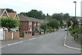
3
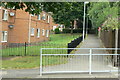
Hadrian Gardens
Pedestrian access to the fronts of the houses on this close.
Image: © Alan Murray-Rust
Taken: 20 Jul 2010
0.07 miles
4
Footpath at Ruthwell Gardens
The fence on the right marks the boundary between the public and private sector sections of the final stage of the Top Valley development.
Image: © Alan Murray-Rust
Taken: 20 Jul 2010
0.11 miles
5
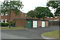
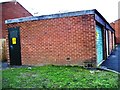
Garages on Bewcastle Road
The nearest one has in fact been commandeered and used for an electrical substation.
Image: © Alan Murray-Rust
Taken: 20 Jul 2010
0.11 miles
6
Tithe Gardens
Vehicle access in this development is separate from pedestrians, on the Radburn principle. These are the backs of the houses.
Image: © Alan Murray-Rust
Taken: 20 Jul 2010
0.11 miles
7
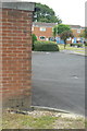
Bench mark, Bewcastle Road
Better seen in the high resolution version. Cut into the end wall of the group of garages seen in http://www.geograph.org.uk/photo/2004955 .
Image: © Alan Murray-Rust
Taken: 20 Jul 2010
0.11 miles
8
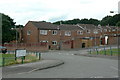
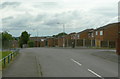
Bewcastle Road
Part of the Top Valley Estate developed by Nottingham City Council in the 1980s, although it was outside the city boundary, in Ashfield District. This part has road names with associations with the north east of England.
Image: © Alan Murray-Rust
Taken: 20 Jul 2010
0.11 miles
9
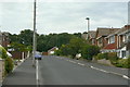
Bracadale Road
The most easterly road in Rise Park Estate.
Image: © Alan Murray-Rust
Taken: 20 Jul 2010
0.12 miles