IMAGES TAKEN NEAR TO
Ballerat Crescent, NOTTINGHAM, NG5 9LJ
Introduction
This page details the photographs taken nearby to Ballerat Crescent, NG5 9LJ by members of the Geograph project.
The Geograph project started in 2005 with the aim of publishing, organising and preserving representative images for every square kilometre of Great Britain, Ireland and the Isle of Man.

There are currently over 7.5m images from over14,400 individuals and you can help contribute to the project by visiting https://www.geograph.org.uk
Image Map
Images are licensed for reuse under creativecommons.org/licenses/by-sa/2.0
Notes
- Clicking on the map will re-center to the selected point.
- The higher the marker number, the further away the image location is from the centre of the postcode.
Image Listing (12 Images Found)
Images are licensed for reuse under creativecommons.org/licenses/by-sa/2.0
Image
Details
Distance
1
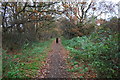
Footpath through woodland strip on east side of A611
Image: © Roger Templeman
Taken: 28 Nov 2017
0.05 miles
2

Pavement and woodland strip beside Hucknall Road (A611)
Ordnance Survey documents indicate that a benchmark levelled at 70.881m above Newlyn Datum was verified in 1979 on a braced concrete post at the side of the road here
Image: © Roger Templeman
Taken: 28 Nov 2017
0.06 miles
3
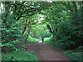
Footpath on the former Leen Valley Railway
The Great Northern Railway's Leen Valley line, built in 1881 to serve collieries in the Leen valley (and extended through Sutton in Ashfield to Langwith in 1898), ran directly ahead and behind the camera until closure in 1968. The Leen Valley line lost its regular passenger service as early as 1929.
Image: © John Sutton
Taken: 6 May 2011
0.17 miles
4
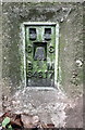
Benchmark on Bulwell Forest Golf Course triangulation pillar
Ordnance Survey flush bracket (serial identifier S4617) benchmark described on the Bench Mark Database at http://www.bench-marks.org.uk/bm6070
Image: © Roger Templeman
Taken: 28 Nov 2017
0.20 miles
5

Bulwell Forest Golf Course
There is an Ordnance Survey trig point pillar, http://trigpointing.uk/trig/3402 near the right hand edge of the image. The pillar has a flush bracket benchmark Image on the right hand face of the pillar.
Image: © Roger Templeman
Taken: 28 Nov 2017
0.21 miles

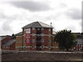
7
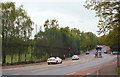
Bestwood NG5, Notts.
Anti-stray golf ball netting at the side of the Bulwell Forest Municipal Golf Course. The three cars on the left are travelling along Hucknall Road (the A611) in the direction of Moor Bridge, whilst the blue car on the right is turning into Top Valley Way.
Image: © David Hallam-Jones
Taken: 17 May 2013
0.22 miles
8
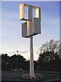
Wind Turbine at Tesco, Nottingham
This wind turbine stands in the car park of the Tesco store at Top Valley, Nottingham. Vertical axis wind turbines such as this one are better suited to urban environments where there may be no predominant wind direction, perhaps due to the built up surroundings. The more familiar three-blade horizontal axis ones will generally be more efficient in a steady air flow. See http://www.greenbuildingforum.co.uk/newforum/comments.php?DiscussionID=2523 and http://www.tesco.com/greenerliving/what_we_are_doing/reducing_energy_use/default.page?
Update, June 2011: This wind turbine is no longer there, although I am not sure when, or why, it was removed.
Image: © Lynne Kirton
Taken: 14 Nov 2008
0.23 miles
10
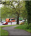
Bestwood NG5, Notts.
Anti-stray golf ball fencing at the side of the Bulwell Forest Municipal Golf Course, on one side of Hucknall Road (the A611). This is the view from a footpath that connects the Top Valley Tesco supermarket - behind the photographer - with the nearest bus stop.
Image: © David Hallam-Jones
Taken: 17 May 2013
0.24 miles