IMAGES TAKEN NEAR TO
Ranskill Gardens, NOTTINGHAM, NG5 9DX
Introduction
This page details the photographs taken nearby to Ranskill Gardens, NG5 9DX by members of the Geograph project.
The Geograph project started in 2005 with the aim of publishing, organising and preserving representative images for every square kilometre of Great Britain, Ireland and the Isle of Man.

There are currently over 7.5m images from over14,400 individuals and you can help contribute to the project by visiting https://www.geograph.org.uk
Image Map
Images are licensed for reuse under creativecommons.org/licenses/by-sa/2.0
Notes
- Clicking on the map will re-center to the selected point.
- The higher the marker number, the further away the image location is from the centre of the postcode.
Image Listing (6 Images Found)
Images are licensed for reuse under creativecommons.org/licenses/by-sa/2.0
Image
Details
Distance
1
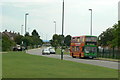
Ridgeway or Ridge Way
Road name signs have been inconsistent over the years as to whether it should be one word or two.
Image: © Alan Murray-Rust
Taken: 20 Jul 2010
0.20 miles
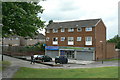
3

Kyle View
Part of the Top Valley housing development. Vehicle access to the rear of premises, with front access provided by pedestrian walkways.
Image: © Alan Murray-Rust
Taken: 20 Jul 2010
0.21 miles
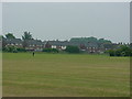
4
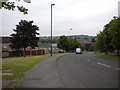
Horsham Drive, Top Valley
Seen from Old Farm Road, with the southern end of Knights Close visible on the right.
Image: © Richard Vince
Taken: 11 Jun 2013
0.22 miles
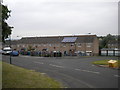
5
Kyle View shops
Now looking depressingly run down, but at least still serving a local need.
Image: © Alan Murray-Rust
Taken: 20 Jul 2010
0.23 miles
6
South end of Old Farm Road, Top Valley
Image: © Richard Vince
Taken: 11 Jun 2013
0.24 miles