IMAGES TAKEN NEAR TO
Pine Hill Close, NOTTINGHAM, NG5 9DA
Introduction
This page details the photographs taken nearby to Pine Hill Close, NG5 9DA by members of the Geograph project.
The Geograph project started in 2005 with the aim of publishing, organising and preserving representative images for every square kilometre of Great Britain, Ireland and the Isle of Man.

There are currently over 7.5m images from over14,400 individuals and you can help contribute to the project by visiting https://www.geograph.org.uk
Image Map
Images are licensed for reuse under creativecommons.org/licenses/by-sa/2.0
Notes
- Clicking on the map will re-center to the selected point.
- The higher the marker number, the further away the image location is from the centre of the postcode.
Image Listing (34 Images Found)
Images are licensed for reuse under creativecommons.org/licenses/by-sa/2.0
Image
Details
Distance
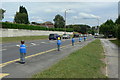
1
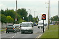
Temporary speed limit
Operating at school opening and closing times and incorporating a patrolled crossing.
Image: © Alan Murray-Rust
Taken: 20 Jul 2010
0.04 miles
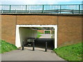
3
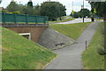
Subway access
At the roundabout at the junction of Top Valley Drive and Old Farm Road.
Image: © Alan Murray-Rust
Taken: 20 Jul 2010
0.04 miles
4
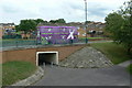
Purple patch
A bus in garish advertising livery passes over a subway on Old Farm Road
Image: © Alan Murray-Rust
Taken: 20 Jul 2010
0.06 miles
6
School sentries
On Bestwood Park Drive alongside Rise Park Primary School.
Image: © Alan Murray-Rust
Taken: 20 Jul 2010
0.07 miles
7
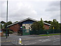
North Nottingham e-Learning Centre, Top Valley Drive
Image: © Oxymoron
Taken: 4 Sep 2008
0.08 miles
8
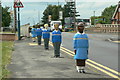
School sentries
On Bestwood Park Drive alongside Rise Park Primary School. Despite the presence of the subway, a crossing point has been created at road level which is patrolled at school starting and finishing times http://www.geograph.org.uk/photo/2005137 .
Image: © Alan Murray-Rust
Taken: 20 Jul 2010
0.08 miles
9
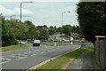
Roundabout on Bestwood Park Drive
At the junction with Top Valley Way and Muirfield Road.
Image: © Alan Murray-Rust
Taken: 20 Jul 2010
0.09 miles
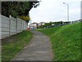
10
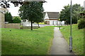
Footpath in Top Valley
One of the principal pedestrian routes through the estate, where pedestrian and vehicle routes are largely separated.
pede
Image: © Alan Murray-Rust
Taken: 20 Jul 2010
0.09 miles