IMAGES TAKEN NEAR TO
Ramsdale Park, NOTTINGHAM, NG5 8PT
Introduction
This page details the photographs taken nearby to Ramsdale Park, NG5 8PT by members of the Geograph project.
The Geograph project started in 2005 with the aim of publishing, organising and preserving representative images for every square kilometre of Great Britain, Ireland and the Isle of Man.

There are currently over 7.5m images from over14,400 individuals and you can help contribute to the project by visiting https://www.geograph.org.uk
Image Map
Images are licensed for reuse under creativecommons.org/licenses/by-sa/2.0
Notes
- Clicking on the map will re-center to the selected point.
- The higher the marker number, the further away the image location is from the centre of the postcode.
Image Listing (27 Images Found)
Images are licensed for reuse under creativecommons.org/licenses/by-sa/2.0
Image
Details
Distance
1
Cockpit Hill Vicinity, Calverton, Notts.
This semi-circular track encompasses part of Cockpit Hill, site of a former 'minor' Roman encampment. Hollinwood Lane that bisects Ramsdale Park Golf Course in the valley may, it seems, have formed part of a Roman road from Cockpit Hill to Oxton. A half-hidden sign declares this track to Ramsdale Stables (now residential) to be "private".
Image: © David Hallam-Jones
Taken: 1 Oct 2015
0.06 miles
2
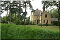
Gardeners Cottage
Former estate houses attached to Abbey House.
Image: © Alan Murray-Rust
Taken: 20 Jul 2010
0.07 miles
3
Ramsdale Park Vicinity, Calverton, Notts.
A tee stop rather than a "tea stop", unless you have a flask with you. This is one of the highest points of Ramsdale Park Golf Course. Note the stile and finger post on the left. Behind the finger post and behind the trees can be found the Cockpit Hill location of a former Roman (defensive) camp.
Image: © David Hallam-Jones
Taken: 1 Oct 2015
0.08 miles
4
Ramsdale Park Golf Course, Calverton, Notts.
A backwards glance to one of the golf course's highest points from a semi-circular track that semi-encapsulates Cockpit Hill, site of a former 'minor' Roman encampment. Hollinwood Lane, lower down in the valley may, it seems, have formed part of a Roman Road from Cockpit Hill to Oxton.
Image: © David Hallam-Jones
Taken: 1 Oct 2015
0.08 miles
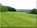
5
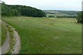
Ramsdale Park Golf Course, Calverton, Notts.
A magnificent 'resting' place and/or viewpoint on a fine day.
Image: © David Hallam-Jones
Taken: 1 Oct 2015
0.09 miles
6
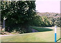
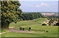
Ramsdale Park Golf Centre
Looking north west from Ramsdale Hill. The path left is a public right of way through the course.
Image: © Alan Murray-Rust
Taken: 20 Jul 2010
0.10 miles
7
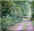
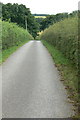
The lane to Ramsdale Cottage
One of the drives into the original Ramsdale Park estate. It is also a public footpath.
Image: © Alan Murray-Rust
Taken: 6 Jun 2023
0.11 miles
8
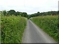
Lane to Ramsdale Park
The original drive to Ramsdale Park and Abbey House. Private road, but public bridleway.
Image: © Alan Murray-Rust
Taken: 20 Jul 2010
0.11 miles
9
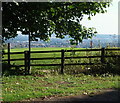
View from Ramsdale Hill
Formerly part of the parkland surrounding Abbey House, now a golf course.
Image: © Alan Murray-Rust
Taken: 6 Jun 2023
0.11 miles
10
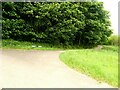
Parting of the ways
Access to the 11th (left) and 14th (right) tees of the Seely course in Ramsdale Park Golf Centre. The main path is also a public footpath.
Image: © Alan Murray-Rust
Taken: 6 Jun 2023
0.12 miles