IMAGES TAKEN NEAR TO
Mansfield Road, NOTTINGHAM, NG5 8PN
Introduction
This page details the photographs taken nearby to Mansfield Road, NG5 8PN by members of the Geograph project.
The Geograph project started in 2005 with the aim of publishing, organising and preserving representative images for every square kilometre of Great Britain, Ireland and the Isle of Man.

There are currently over 7.5m images from over14,400 individuals and you can help contribute to the project by visiting https://www.geograph.org.uk
Image Map
Images are licensed for reuse under creativecommons.org/licenses/by-sa/2.0
Notes
- Clicking on the map will re-center to the selected point.
- The higher the marker number, the further away the image location is from the centre of the postcode.
Image Listing (6 Images Found)
Images are licensed for reuse under creativecommons.org/licenses/by-sa/2.0
Image
Details
Distance
1
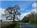
An oak tree beside the A60
A terrible road for cycling on!
Image: © David Lally
Taken: 2 Apr 2024
0.05 miles
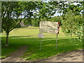
3
Sherwood Lodge, Nottinghamshire Police HQ
Hidden away in Burntstump Country Park
Image: © Chris Morgan
Taken: 4 Apr 2016
0.16 miles
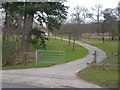
5
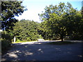
Upper car park, Burntstump Country Park
Surprisingly empty on a sunny, warm Sunday afternoon in September.
Image: © Richard Vince
Taken: 29 Sep 2013
0.21 miles
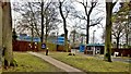
6
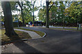
The entrance to Sherwood Lodge
The joint HQ of Nottinghamshire Police and Fire and Rescue Service. The public cannot go beyond this point.
Image: © Bill Boaden
Taken: 15 Oct 2022
0.23 miles