IMAGES TAKEN NEAR TO
Mansfield Road, NOTTINGHAM, NG5 8PJ
Introduction
This page details the photographs taken nearby to Mansfield Road, NG5 8PJ by members of the Geograph project.
The Geograph project started in 2005 with the aim of publishing, organising and preserving representative images for every square kilometre of Great Britain, Ireland and the Isle of Man.

There are currently over 7.5m images from over14,400 individuals and you can help contribute to the project by visiting https://www.geograph.org.uk
Image Map
Images are licensed for reuse under creativecommons.org/licenses/by-sa/2.0
Notes
- Clicking on the map will re-center to the selected point.
- The higher the marker number, the further away the image location is from the centre of the postcode.
Image Listing (7 Images Found)
Images are licensed for reuse under creativecommons.org/licenses/by-sa/2.0
Image
Details
Distance
1
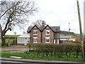
Duke's Cottages
Seen from Mansfield Road.
Image: © Michael Dibb
Taken: 31 Mar 2017
0.00 miles
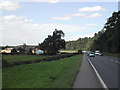
2
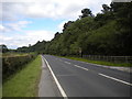
A60 Mansfield Road north of Arnold
Looking towards the Seven Mile Inn and Mansfield, with Turnpike Plantation on the right.
Image: © Richard Vince
Taken: 12 Aug 2017
0.03 miles
3
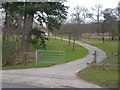
![Driveway to the manor [2]](https://s1.geograph.org.uk/geophotos/05/35/07/5350793_54ce6958_120x120.jpg)
Driveway to the manor [2]
According to the sign where the driveway leaves the A60 road this leads to Birchwood Park Manor. OS maps however have it leading to Birchwood House. See Image
Image: © Michael Dibb
Taken: 31 Mar 2017
0.03 miles
4
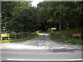
Drive to Birchwood Park Manor
Seen from the A60 north of Arnold.
Image: © Richard Vince
Taken: 12 Aug 2017
0.03 miles
5
![Driveway to the manor [1]](https://s0.geograph.org.uk/geophotos/05/35/07/5350788_b99e7938_120x120.jpg)
Driveway to the manor [1]
According to the sign where the driveway leaves the A60 road this leads to Birchwood Park Manor. OS maps however have it leading to Birchwood House. See Image
Image: © Michael Dibb
Taken: 31 Mar 2017
0.07 miles
6
Duke's Cottages
by the side of the busy A60, 7 miles to Mansfield
Image: © Tom Courtney
Taken: 8 Aug 2005
0.16 miles