IMAGES TAKEN NEAR TO
Mansfield Road, NOTTINGHAM, NG5 8PH
Introduction
This page details the photographs taken nearby to Mansfield Road, NG5 8PH by members of the Geograph project.
The Geograph project started in 2005 with the aim of publishing, organising and preserving representative images for every square kilometre of Great Britain, Ireland and the Isle of Man.

There are currently over 7.5m images from over14,400 individuals and you can help contribute to the project by visiting https://www.geograph.org.uk
Image Map
Images are licensed for reuse under creativecommons.org/licenses/by-sa/2.0
Notes
- Clicking on the map will re-center to the selected point.
- The higher the marker number, the further away the image location is from the centre of the postcode.
Image Listing (9 Images Found)
Images are licensed for reuse under creativecommons.org/licenses/by-sa/2.0
Image
Details
Distance
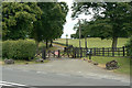
1
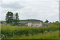
Bottomhouse Farm
Alongside the Nottingham - Mansfield road near Papplewick.
Image: © Alan Murray-Rust
Taken: 6 Jul 2010
0.00 miles
2
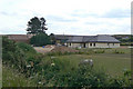
Bottomhouse Farm
New residential building on the north side of the farm.
Image: © Alan Murray-Rust
Taken: 6 Jul 2010
0.05 miles
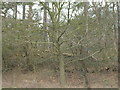
3
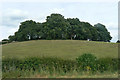
Clump of trees
This appears to be an ornamental group of trees, associated with Forest Farm.
Image: © Alan Murray-Rust
Taken: 6 Jul 2010
0.13 miles
5
Entrance to Forest Farm
The western entrance on the A60 near Bestwood Pumping Station.
Image: © Alan Murray-Rust
Taken: 6 Jul 2010
0.18 miles
7
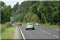
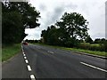
A60 Nottingham - Mansfield road
Alongside Ramper Covert.
Image: © Alan Murray-Rust
Taken: 6 Jul 2010
0.22 miles
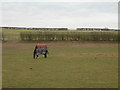
9
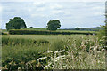
Fields alongside the A60
A selection of typical roadside flora in the foreground.
Image: © Alan Murray-Rust
Taken: 6 Jul 2010
0.24 miles