IMAGES TAKEN NEAR TO
Pavilion Road, NOTTINGHAM, NG5 8NL
Introduction
This page details the photographs taken nearby to Pavilion Road, NG5 8NL by members of the Geograph project.
The Geograph project started in 2005 with the aim of publishing, organising and preserving representative images for every square kilometre of Great Britain, Ireland and the Isle of Man.

There are currently over 7.5m images from over14,400 individuals and you can help contribute to the project by visiting https://www.geograph.org.uk
Image Map
Images are licensed for reuse under creativecommons.org/licenses/by-sa/2.0
Notes
- Clicking on the map will re-center to the selected point.
- The higher the marker number, the further away the image location is from the centre of the postcode.
Image Listing (55 Images Found)
Images are licensed for reuse under creativecommons.org/licenses/by-sa/2.0
Image
Details
Distance
1
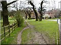
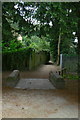
Pedestrian Shortcut into the Bestwood Lodge Woods
Image: © Mick Garratt
Taken: 22 Apr 2006
0.07 miles
2
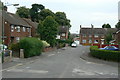
Treegarth Square
The northern end of the Bestwood Park estate, a small group of houses filling the space between Bestwood Park Drive and the city boundary.
Image: © Alan Murray-Rust
Taken: 20 Jul 2010
0.09 miles
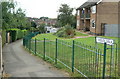
3
Cedar Tree Road
This small housing development was originally armed forces housing, dating from the period when Bestwood Lodge was a Ministry of Defence centre. It has since reverted to private ownerships.
Image: © Alan Murray-Rust
Taken: 20 Jul 2010
0.10 miles
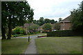
4
Evedon Walk
Maisonette block at the northern end of Bestwood Park estate.
Image: © Alan Murray-Rust
Taken: 20 Jul 2010
0.11 miles
5
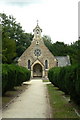
Former lych gate, Emmanuel Church
The original site at the east end of the churchyard.
On another website a 'Local parishioner' writes:
"The lychgate has recently (2009) been relocated to the other side of the church yard. This was done in order that it might be saved from destruction through repeated acts of vandalism. The stone walls remain in position but the steps have recently been covered over by a ramp. The relocated wooden structure has been resited on new stone work. The original location had been the main entrance into the church yard but had fallen into disuse due to modern housing developments surrounding the church. The new location means that the lychgate functions once again as it was intended.
I believe that English heritage have lost interest in it being a listed structure now that it has been moved."
The lych gate can be seen in its new location in http://www.geograph.org.uk/photo/2005013 .
Image: © Alan Murray-Rust
Taken: 20 Jul 2010
0.11 miles
7
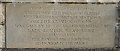
Emmanuel Church, Warren Hill - Dedication Plaque
Image: © Oxymoron
Taken: 12 Nov 2008
0.13 miles
8
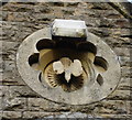
Emmanuel Church, Warren Hill - Detail
Someone has placed a modern light on the frame of this beautiful little exterior carving - surely they could have found a less sensitive spot?
Image: © Oxymoron
Taken: 12 Nov 2008
0.13 miles
9
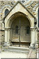
Memorial alcove
Attached to the west end of Emmanuel Church, the alcove is a memorial to one of the Duchesses of St Albans. Described as a porch in the English Heritage listing.
Image: © Alan Murray-Rust
Taken: 20 Jul 2010
0.13 miles
10
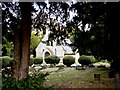
Emmanuel Church
Built in 1867 to the design of S.S.Teulon essentially as the private chapel for Bestwood Lodge, the home of the Dukes of St Albans, but now the local parish church. Listed Grade II.
This is now the main access to the church, following the housing developments of the 1980s in the area. What appears to be a west door is in fact a memorial alcove to one of the duchesses, see http://www.geograph.org.uk/photo/2005005 .
Image: © Alan Murray-Rust
Taken: 20 Jul 2010
0.13 miles