IMAGES TAKEN NEAR TO
Church Lane, NOTTINGHAM, NG5 8HG
Introduction
This page details the photographs taken nearby to Church Lane, NG5 8HG by members of the Geograph project.
The Geograph project started in 2005 with the aim of publishing, organising and preserving representative images for every square kilometre of Great Britain, Ireland and the Isle of Man.

There are currently over 7.5m images from over14,400 individuals and you can help contribute to the project by visiting https://www.geograph.org.uk
Image Map
Images are licensed for reuse under creativecommons.org/licenses/by-sa/2.0
Notes
- Clicking on the map will re-center to the selected point.
- The higher the marker number, the further away the image location is from the centre of the postcode.
Image Listing (52 Images Found)
Images are licensed for reuse under creativecommons.org/licenses/by-sa/2.0
Image
Details
Distance
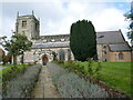
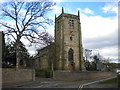
3

Lavender walk
The main approach to St Mary's Church, Arnold.
Image: © Alan Murray-Rust
Taken: 12 Aug 2021
0.02 miles
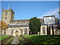
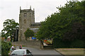
4
St Mary's church, Arnold
Largely medieval parish church https://historicengland.org.uk/listing/the-list/list-entry/1235987?section=official-list-entry
Image: © Jonathan Thacker
Taken: 3 Nov 2023
0.02 miles
5
St Mary's church, Arnold
Both the church https://historicengland.org.uk/listing/the-list/list-entry/1235987?section=official-list-entry and the boundary wall https://historicengland.org.uk/listing/the-list/list-entry/1227479?section=official-list-entry are listed.
Image: © Jonathan Thacker
Taken: 3 Nov 2023
0.02 miles
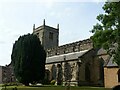
6
St Mary's Church, Arnold
On Church Lane, appropriately enough.
Image: © Richard Vince
Taken: 22 Mar 2014
0.03 miles
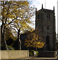
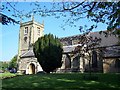
7
St Mary's Church, Arnold
Photos from the 1950s show a much more open view of the church from this angle. There has been substantial tree growth in the meantime.
Image: © Alan Murray-Rust
Taken: 6 Jul 2010
0.03 miles
8
Arnold, Nottinghamshire
Recreating this 'First' for the square https://www.geograph.org.uk/photo/32037 . The title is taken from the original; this is St Mary's Church, to be specific.
Image: © Alan Murray-Rust
Taken: 12 Aug 2021
0.03 miles
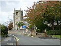
10
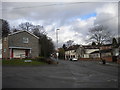
Bottom of Church Lane, Arnold
The junction of Church Lane (left) and Church Street. Appropriately, the church in question is in the V between the two, partially hidden by the house on the left.
Image: © Richard Vince
Taken: 22 Mar 2014
0.03 miles