IMAGES TAKEN NEAR TO
Redhill Road, NOTTINGHAM, NG5 8HB
Introduction
This page details the photographs taken nearby to Redhill Road, NG5 8HB by members of the Geograph project.
The Geograph project started in 2005 with the aim of publishing, organising and preserving representative images for every square kilometre of Great Britain, Ireland and the Isle of Man.

There are currently over 7.5m images from over14,400 individuals and you can help contribute to the project by visiting https://www.geograph.org.uk
Image Map
Images are licensed for reuse under creativecommons.org/licenses/by-sa/2.0
Notes
- Clicking on the map will re-center to the selected point.
- The higher the marker number, the further away the image location is from the centre of the postcode.
Image Listing (65 Images Found)
Images are licensed for reuse under creativecommons.org/licenses/by-sa/2.0
Image
Details
Distance
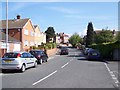
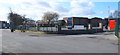
2
Redhill Stores
The fascia panel shows where the words 'Post Office' have been removed. It was one of the ones deemed superfluous in the recent cuts.
Image: © Alan Murray-Rust
Taken: 6 Jul 2010
0.05 miles
3
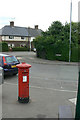
Redhill Post Office postbox Ref NG5 417
GVIR pillar box, still showing the remains of the 'Post Office' sign on the top. The Post Office too is no longer there.
Image: © Alan Murray-Rust
Taken: 6 Jul 2010
0.06 miles
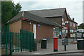
4
Redhill School
As with many schools, this also functions as the local Leisure Centre.
Image: © Alan Murray-Rust
Taken: 6 Jul 2010
0.06 miles
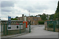
5
Redhill, NG5, Notts.
Redhill Academy's main entrance off Redhill Road.
Image: © David Hallam-Jones
Taken: 16 Feb 2014
0.07 miles
6
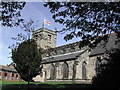
Arnold, Nottinghamshire
St Mary's Church dates back to 1176. This photo was taken on a very bright St George's Day 2004.
Image: © Tom Courtney
Taken: 23 Apr 2004
0.09 miles
7

Church Lane Recreation Ground, Arnold
Image: © Jonathan Thacker
Taken: 3 Nov 2023
0.11 miles
8
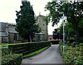
Arnold, Notts (St Mary's)
A view of St Mary's Church from Church Lane. A church has existed here since 1270 when the family of Arnehall, or Arnold, when were influential in the area. As an example, Ralph de Arnehall was created a knight by Edward I in 1278. The chancel has been dated to the fourteenth century when the Earls of Hereford were notable local land owners.
Image: © David Hallam-Jones
Taken: 12 Jul 2012
0.12 miles
9

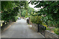
Access to Church Lane
A vehicular route from St Mary's church.
Image: © Jonathan Thacker
Taken: 3 Nov 2023
0.13 miles
10
Allen's Walk
An old established footpath which although being developed with housing, has managed to avoid becoming a vehicle thoroughfare.
Image: © Alan Murray-Rust
Taken: 6 Jul 2010
0.13 miles