IMAGES TAKEN NEAR TO
Mapperley Orchard, NOTTINGHAM, NG5 8AH
Introduction
This page details the photographs taken nearby to Mapperley Orchard, NG5 8AH by members of the Geograph project.
The Geograph project started in 2005 with the aim of publishing, organising and preserving representative images for every square kilometre of Great Britain, Ireland and the Isle of Man.

There are currently over 7.5m images from over14,400 individuals and you can help contribute to the project by visiting https://www.geograph.org.uk
Image Map
Images are licensed for reuse under creativecommons.org/licenses/by-sa/2.0
Notes
- Clicking on the map will re-center to the selected point.
- The higher the marker number, the further away the image location is from the centre of the postcode.
Image Listing (18 Images Found)
Images are licensed for reuse under creativecommons.org/licenses/by-sa/2.0
Image
Details
Distance
1
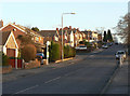
Coppice Road
The final steep section up to the ridge of Mapperley Plains.
Image: © Alan Murray-Rust
Taken: 18 Jan 2009
0.10 miles
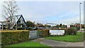
2
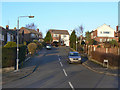
Mapperley Orchard
1960s development off Coppice Road.
Image: © Alan Murray-Rust
Taken: 18 Jan 2009
0.11 miles
3
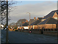
Ramsey Drive
The east side of the north end of Ramsey Drive remained open ground for a long time after the main development was complete but has been relatively recently filled in with large houses, the most prominent feature of which appears to be the 2 or 3 car garages.
Image: © Alan Murray-Rust
Taken: 18 Jan 2009
0.16 miles
4
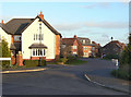
Corncrake Drive
Part of the more recent development at the north end of Ramsey Drive.
Image: © Alan Murray-Rust
Taken: 18 Jan 2009
0.17 miles
5
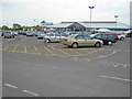
Brookfields Garden Centre
Large garden centre just off Mapperley Plains (B684) east of Arnold. Also sells clothes, toys, food, etc and has a large cafe.
http://www.brookfieldsgardencentre.co.uk/
Image: © Trevor Rickard
Taken: 3 Jul 2011
0.17 miles
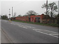
6
Remains of Middlebeck Farm
Recreating this 'First' for the square http://www.geograph.org.uk/photo/34674
Image: © Alan Murray-Rust
Taken: 26 May 2021
0.19 miles
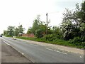
7
Remains of Middlebeck Farm
Near the junction of Coppice Road and Mapperley Plains
Image: © Tom Courtney
Taken: 15 Apr 2004
0.19 miles
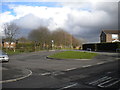
8
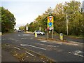
Mini roundabout
At the junction of Mapperley Plains and Coppice Road.
Image: © Graham Hogg
Taken: 8 Nov 2021
0.19 miles
10
Bus turning circle, Newcombe Drive, Plains Estate
This turning circle, at the end of Newcombe Drive and sort of built into its junction with Darlton Drive (foreground), was largely unused for several years, the main bus service through Plains Estate continuing along Ramsey Drive and then via Coppice Road to Arnold (rather than serving Newcombe Drive). However, nine days after this photograph was taken, Nottingham City Transport introduced route 57, which serves Newcombe Drive half hourly during the day, and terminates here. Hopefully the car on the extreme left is no longer parked there.
Image: © Richard Vince
Taken: 22 Mar 2014
0.21 miles