IMAGES TAKEN NEAR TO
Welham Crescent, NOTTINGHAM, NG5 7LJ
Introduction
This page details the photographs taken nearby to Welham Crescent, NG5 7LJ by members of the Geograph project.
The Geograph project started in 2005 with the aim of publishing, organising and preserving representative images for every square kilometre of Great Britain, Ireland and the Isle of Man.

There are currently over 7.5m images from over14,400 individuals and you can help contribute to the project by visiting https://www.geograph.org.uk
Image Map
Images are licensed for reuse under creativecommons.org/licenses/by-sa/2.0
Notes
- Clicking on the map will re-center to the selected point.
- The higher the marker number, the further away the image location is from the centre of the postcode.
Image Listing (6 Images Found)
Images are licensed for reuse under creativecommons.org/licenses/by-sa/2.0
Image
Details
Distance
1
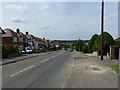
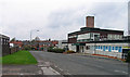
Gedling Road, Arnold
Part of the historic road network, with housing developed in the post-WW2 period.
Image: © Alan Murray-Rust
Taken: 12 Aug 2021
0.15 miles
2
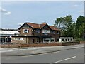
The Major Oak, Rolleston Drive
1960s pub, contemporary with the development of Rolleston Drive.
Image: © Alan Murray-Rust
Taken: 12 Aug 2021
0.17 miles
3
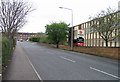
Brookfield Road eastwards
Howdens Joinery Company is to the right.
Image: © Andrew Tatlow
Taken: 11 Apr 2009
0.18 miles
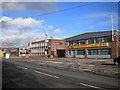
5
Brookfield Road westwards
The John Lewis Partnership Nottingham Customer Collections depot is to the right.
Image: © Andrew Tatlow
Taken: 11 Apr 2009
0.22 miles
6
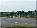
Ripe for new housing?
This was the Nottinghamshire County Council's central workshops and Training Centre, closed around 2010 and demolished c.2016.
Image: © Alan Murray-Rust
Taken: 12 Aug 2021
0.24 miles