IMAGES TAKEN NEAR TO
Coppice Road, NOTTINGHAM, NG5 7HW
Introduction
This page details the photographs taken nearby to Coppice Road, NG5 7HW by members of the Geograph project.
The Geograph project started in 2005 with the aim of publishing, organising and preserving representative images for every square kilometre of Great Britain, Ireland and the Isle of Man.

There are currently over 7.5m images from over14,400 individuals and you can help contribute to the project by visiting https://www.geograph.org.uk
Image Map
Images are licensed for reuse under creativecommons.org/licenses/by-sa/2.0
Notes
- Clicking on the map will re-center to the selected point.
- The higher the marker number, the further away the image location is from the centre of the postcode.
Image Listing (18 Images Found)
Images are licensed for reuse under creativecommons.org/licenses/by-sa/2.0
Image
Details
Distance
3
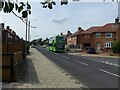
Lime line service 58 on Birchfield Road
Service 58 is the principal service from Nottingham to the Arnold area, running at least every 10 minutes Monday to Saturday daytime. Seen here is one of Nottingham City Transport's large fleet of biogas-powered buses.
Image: © Alan Murray-Rust
Taken: 12 Aug 2021
0.21 miles
4
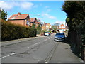
Birchfield Road at Hawthorn Crescent
This is part of the main bus route through the estates to the north and north-east of Arnold.
Image: © Alan Murray-Rust
Taken: 6 Jul 2010
0.21 miles
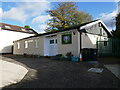
7
Pondhills Lane Community and Arts Centre, Arnold
Image: © Jonathan Thacker
Taken: 3 Nov 2023
0.23 miles
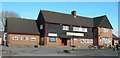
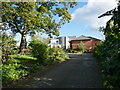
8
Pondhills Lane Community Centre
Making use of a former Victorian school. The very constricted access of Calverton Road has been walled up, so you have to go round the back.
Image: © Alan Murray-Rust
Taken: 6 Jul 2010
0.23 miles
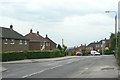
9
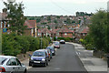
Hawthorn Crescent
Part of the extensive housing development of the 1950s to the north of Arnold.
Image: © Alan Murray-Rust
Taken: 6 Jul 2010
0.23 miles
10
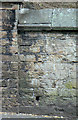
Bench mark on Calverton Road
Cut in the retaining wall of a former school, now the Pondhills Lane Community Centre
Image: © Alan Murray-Rust
Taken: 6 Jul 2010
0.24 miles