IMAGES TAKEN NEAR TO
Langford Road, NOTTINGHAM, NG5 7HP
Introduction
This page details the photographs taken nearby to Langford Road, NG5 7HP by members of the Geograph project.
The Geograph project started in 2005 with the aim of publishing, organising and preserving representative images for every square kilometre of Great Britain, Ireland and the Isle of Man.

There are currently over 7.5m images from over14,400 individuals and you can help contribute to the project by visiting https://www.geograph.org.uk
Image Map
Images are licensed for reuse under creativecommons.org/licenses/by-sa/2.0
Notes
- Clicking on the map will re-center to the selected point.
- The higher the marker number, the further away the image location is from the centre of the postcode.
Image Listing (15 Images Found)
Images are licensed for reuse under creativecommons.org/licenses/by-sa/2.0
Image
Details
Distance
2
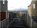
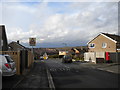
Public footpath to Langford Road, Plains Estate
This footpath links Darlton Drive, in Plains Estate (and on the pavement of which the photographer is standing), with Langford Road, which is in an area of council housing off Rolleston Drive on the eastern edge of Arnold.
Image: © Richard Vince
Taken: 22 Mar 2014
0.04 miles
3
The King's Centre, Shirley Drive, Arnold
The premises of The King's Church, Arnold, occupied by them since 2002.
Image: © Richard Vince
Taken: 22 Mar 2014
0.09 miles
6
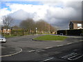
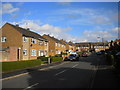
Bus turning circle, Newcombe Drive, Plains Estate
This turning circle, at the end of Newcombe Drive and sort of built into its junction with Darlton Drive (foreground), was largely unused for several years, the main bus service through Plains Estate continuing along Ramsey Drive and then via Coppice Road to Arnold (rather than serving Newcombe Drive). However, nine days after this photograph was taken, Nottingham City Transport introduced route 57, which serves Newcombe Drive half hourly during the day, and terminates here. Hopefully the car on the extreme left is no longer parked there.
Image: © Richard Vince
Taken: 22 Mar 2014
0.15 miles
8
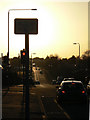
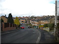
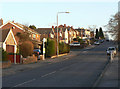
Looking down Rolleston Drive
Late afternoon sun at the junction of Coppice Road.
Image: © Alan Murray-Rust
Taken: 18 Jan 2009
0.17 miles
9
Coppice Road
The final steep section up to the ridge of Mapperley Plains.
Image: © Alan Murray-Rust
Taken: 18 Jan 2009
0.17 miles
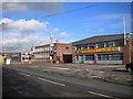
10
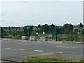
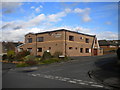
Ripe for new housing?
This was the Nottinghamshire County Council's central workshops and Training Centre, closed around 2010 and demolished c.2016.
Image: © Alan Murray-Rust
Taken: 12 Aug 2021
0.17 miles