IMAGES TAKEN NEAR TO
Runswick Drive, NOTTINGHAM, NG5 7GW
Introduction
This page details the photographs taken nearby to Runswick Drive, NG5 7GW by members of the Geograph project.
The Geograph project started in 2005 with the aim of publishing, organising and preserving representative images for every square kilometre of Great Britain, Ireland and the Isle of Man.

There are currently over 7.5m images from over14,400 individuals and you can help contribute to the project by visiting https://www.geograph.org.uk
Image Map
Images are licensed for reuse under creativecommons.org/licenses/by-sa/2.0
Notes
- Clicking on the map will re-center to the selected point.
- The higher the marker number, the further away the image location is from the centre of the postcode.
Image Listing (21 Images Found)
Images are licensed for reuse under creativecommons.org/licenses/by-sa/2.0
Image
Details
Distance
3
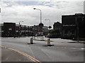
Front St, Arnold
View is from the junction of Front Street and Coppice Road
Image: © Tom Courtney
Taken: 9 Aug 2005
0.18 miles
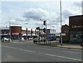
4

Front Street
A deserted high street for any last minute Christmas shopping.
Image: © Mick Garratt
Taken: 24 Dec 2007
0.19 miles
5
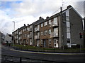
Flats at the bottom of Church Street, Arnold
Three blocks of low rise flats at the north end of Arnold town centre.
Image: © Richard Vince
Taken: 22 Mar 2014
0.19 miles
6
Front St, Arnold
Recreating this 'First' for the square http://www.geograph.org.uk/photo/35572 . Not quite the precise camera location as the junction was remodelled in around 2015 and I would have had to have been standing in the middle of a busy road.
Image: © Alan Murray-Rust
Taken: 12 Aug 2021
0.19 miles
7

Front Street
The main shopping street in Arnold. This is the northern end which has been more substantially redeveloped than the southern part.
Image: © Alan Murray-Rust
Taken: 25 Oct 2009
0.19 miles
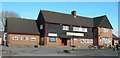
8

Entrance to The Coffee Grinder
See http://www.geograph.org.uk/photo/4788144 Formerly The Lord Nelson, a Home Ales pub. The 1923 date clearly relates to the modernisation of the pub front, when a new terracotta frontage was added, as the building is significantly older than this.
Image: © Alan Murray-Rust
Taken: 27 Jul 2016
0.19 miles
9
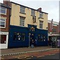
Former Lord Nelson
See Image Now owned by the Blue Monkey brewery it would seem and called "The Coffee Grinder" now with a distinctly café air about it.
Image: © David Lally
Taken: 8 Jan 2016
0.20 miles
10
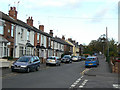
Worrall Avenue, Arnold
This shows an interesting progression of house styles as you get further along the road, clearly showing increasingly later dates of development.
Image: © Alan Murray-Rust
Taken: 25 Oct 2009
0.21 miles