IMAGES TAKEN NEAR TO
Brook Gardens, NOTTINGHAM, NG5 7FD
Introduction
This page details the photographs taken nearby to Brook Gardens, NG5 7FD by members of the Geograph project.
The Geograph project started in 2005 with the aim of publishing, organising and preserving representative images for every square kilometre of Great Britain, Ireland and the Isle of Man.

There are currently over 7.5m images from over14,400 individuals and you can help contribute to the project by visiting https://www.geograph.org.uk
Image Map
Images are licensed for reuse under creativecommons.org/licenses/by-sa/2.0
Notes
- Clicking on the map will re-center to the selected point.
- The higher the marker number, the further away the image location is from the centre of the postcode.
Image Listing (17 Images Found)
Images are licensed for reuse under creativecommons.org/licenses/by-sa/2.0
Image
Details
Distance
1
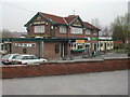
Major Oak Public House
On the corner of Rolleston Drive and Brook Street, Arnold
Image: © Tom Courtney
Taken: 15 Apr 2004
0.08 miles
2
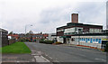
Ripe for new housing?
This was the Nottinghamshire County Council's central workshops and Training Centre, closed around 2010 and demolished c.2016.
Image: © Alan Murray-Rust
Taken: 12 Aug 2021
0.10 miles
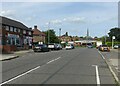
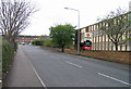
3
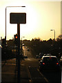
Looking down Rolleston Drive
Late afternoon sun at the junction of Coppice Road.
Image: © Alan Murray-Rust
Taken: 18 Jan 2009
0.11 miles
5
Brookfield Road westwards
The John Lewis Partnership Nottingham Customer Collections depot is to the right.
Image: © Andrew Tatlow
Taken: 11 Apr 2009
0.14 miles
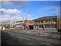
6
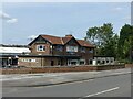
The Major Oak, Rolleston Drive
1960s pub, contemporary with the development of Rolleston Drive.
Image: © Alan Murray-Rust
Taken: 12 Aug 2021
0.15 miles
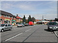
7
Beechwood Road, Arnold
Recreating this 'First' for the square http://www.geograph.org.uk/photo/35574 .
This was the main bus terminus in the area when I first came to Nottingham in the late 70s, but became redundant as a bus route following the development of the Killisick housing estate. Now the only bus service is the night service N58 which operates Friday and Saturday nights only.
Image: © Alan Murray-Rust
Taken: 12 Aug 2021
0.16 miles
8
Beechwood Road, Arnold
This road leads from Coppice Rd on to the Killisick Estate. The estate church is the odd building at the top of the road.
Image: © Tom Courtney
Taken: 9 Aug 2005
0.16 miles
9
Brookfield Road eastwards
Howdens Joinery Company is to the right.
Image: © Andrew Tatlow
Taken: 11 Apr 2009
0.16 miles
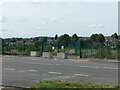
10
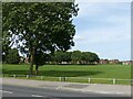
Killisick Recreation Ground
Seen from Coppice Road.
Image: © Alan Murray-Rust
Taken: 12 Aug 2021
0.17 miles