1
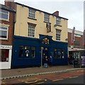
Entrance to The Coffee Grinder
See http://www.geograph.org.uk/photo/4788144 Formerly The Lord Nelson, a Home Ales pub. The 1923 date clearly relates to the modernisation of the pub front, when a new terracotta frontage was added, as the building is significantly older than this.
Image: © Alan Murray-Rust
Taken: 27 Jul 2016
0.00 miles
2
Former Lord Nelson
See
Image Now owned by the Blue Monkey brewery it would seem and called "The Coffee Grinder" now with a distinctly café air about it.
Image: © David Lally
Taken: 8 Jan 2016
0.01 miles
3
Front Street
A deserted high street for any last minute Christmas shopping.
Image: © Mick Garratt
Taken: 24 Dec 2007
0.01 miles
4
Front Street
The main shopping street in Arnold. This is the northern end which has been more substantially redeveloped than the southern part.
Image: © Alan Murray-Rust
Taken: 25 Oct 2009
0.02 miles
5
Front St, Arnold
View is from the junction of Front Street and Coppice Road
Image: © Tom Courtney
Taken: 9 Aug 2005
0.06 miles
6
It must be Sunday
Front Street Arnold without a bus in sight! On weekdays there are around 25 departures an hour so there are normally at least a couple of the stands occupied at any one time.
Image: © Alan Murray-Rust
Taken: 25 Oct 2009
0.06 miles
7
Front St, Arnold
Recreating this 'First' for the square http://www.geograph.org.uk/photo/35572 . Not quite the precise camera location as the junction was remodelled in around 2015 and I would have had to have been standing in the middle of a busy road.
Image: © Alan Murray-Rust
Taken: 12 Aug 2021
0.06 miles
8
High Street, Arnold, Notts.
Arnold's second petrol station opened in December 2017 and it occupies a site previously occupied by Arnold's police station. The station finally closed in 2016 after less than a decade of service. A police contact point now exists within Gedling Borough Council's main office complex in Arnot Hill Park. The stationary car is parked outside a Salvation Army Community Centre & Church, with Chapel Lane immediately beyond it.
Image: © David Hallam-Jones
Taken: 28 Dec 2017
0.07 miles
9
High Street, Arnold, Notts.
This newly opened petrol station (i.e. in December 2017) becomes Arnold's second such establishment. It occupies a site that previously hosted Arnold's police station. The police station finally closed in 2016 after less than a decade of service. A police contact point now exists within Gedling Borough Council's main office complex in Arnot Hill Park.
Image: © David Hallam-Jones
Taken: 28 Dec 2017
0.07 miles
10
Flats at the bottom of Church Street, Arnold
Three blocks of low rise flats at the north end of Arnold town centre.
Image: © Richard Vince
Taken: 22 Mar 2014
0.08 miles


