IMAGES TAKEN NEAR TO
High Street Avenue, NOTTINGHAM, NG5 7DF
Introduction
This page details the photographs taken nearby to High Street Avenue, NG5 7DF by members of the Geograph project.
The Geograph project started in 2005 with the aim of publishing, organising and preserving representative images for every square kilometre of Great Britain, Ireland and the Isle of Man.

There are currently over 7.5m images from over14,400 individuals and you can help contribute to the project by visiting https://www.geograph.org.uk
Image Map
Images are licensed for reuse under creativecommons.org/licenses/by-sa/2.0
Notes
- Clicking on the map will re-center to the selected point.
- The higher the marker number, the further away the image location is from the centre of the postcode.
Image Listing (52 Images Found)
Images are licensed for reuse under creativecommons.org/licenses/by-sa/2.0
Image
Details
Distance
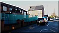
1

High Street Avenue
General vehicle access from High Street is no longer permitted, although emergency and perhaps refuse collection vehicles can still make it over the moulded concrete blocks.
Image: © Alan Murray-Rust
Taken: 25 Oct 2009
0.01 miles
2
Burford Street, Arnold, Notts.
A former Wesleyan Reform Church at the junction of Burford Street and Furlong Street. Furlong Street runs from east to west in front of the tall semi-detached house ahead. This corner plot is identified on historical maps (c.1887) as boasting a "Mission Room" or a 'Gospel Mission Room". The church closed in 2016, affected by a dwindling congregation and was sold at auction in 2017. Following its demolition the church is due to be replaced by a small number of terraced houses. Arnold's High Street is a 2-3 minute walk away behind the photographer, whereas in the distance, a secondary entrance into Arnold Mill Nursery and Primary School can be reached at the far end of Bestwood Avenue.
Image: © David Hallam-Jones
Taken: 15 Feb 2018
0.05 miles
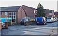
3
Furlong Street, Arnold, Notts.
A former Wesleyan Reform Church at the junction of Furlong Street and Burford Street. The latter, a cul-de-sac, lies on the other side of the church and leads - within minutes - to Arnold's High Street. This former church is identified on historical maps (c.1887) as a "Mission Room" or a 'Gospel Mission Room". It closed in 2016, affected by a dwindling congregation, and was sold at auction in 2017. Following its demolition the church is due to be replaced by a small number of terraced houses. On the left, signposted by a "School" road sign, is a Bestwood Avenue, a residential street that also hosts a secondary entrance into Arnold Mill Nursery and Primary School.
Image: © David Hallam-Jones
Taken: 15 Feb 2018
0.05 miles
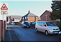
4
Furlong Street, Arnold, Notts.
A former Wesleyan Reform Church at the junction of Furlong Street, on which several vans are parked, and Burford Street with a 'No Through Road' sign. This corner plot is identified on historical maps (c.1887) as boasting a "Mission Room" or a 'Gospel Mission Room". This latter day version of the church closed in 2016, affected by a dwindling congregation. It was sold at auction in 2017 and following its demolition the church is due to be replaced by a small number of terraced houses. High Street is a short walk away, at the eastern end of Burford Street, i.e. within 2-3 minutes.
Image: © David Hallam-Jones
Taken: 15 Feb 2018
0.05 miles
5

Oldest house in Arnold
or so I have been told!! Let me know if you know either way.
Image: © Tom Courtney
Taken: 9 Aug 2005
0.06 miles
6
The Lord Nelson
Public House on Front Street Arnold, near to Asda
Image: © Tom Courtney
Taken: 12 Apr 2004
0.06 miles
7
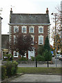
Bonington House
The birthplace of artist Richard Parkes Bonington [1], it's a fine mid-eighteenth century town house. He gives his name to the local theatre.
Image: © Alan Murray-Rust
Taken: 25 Oct 2009
0.09 miles
8
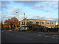
Arnold Health Centre
Conveniently sited in the town centre at the junction of Croft Road and High Street.
Image: © Alan Murray-Rust
Taken: 25 Oct 2009
0.09 miles
9
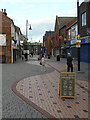
Pedestrianised Front Street
Looking north(ish) from the junction with High Street
Image: © Alan Murray-Rust
Taken: 25 Oct 2009
0.10 miles
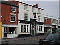
10
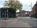
Pedestrianised Front Street
Surprisingly, High Street is not the main shopping street in Arnold, the accolade falling on Front Street. The southern section of the street is pedestrianised, seen here at the junction of Worrall Avenue. On the left is Arnold Methodist Church.
Image: © Alan Murray-Rust
Taken: 25 Oct 2009
0.10 miles