IMAGES TAKEN NEAR TO
Furlong Street, NOTTINGHAM, NG5 7BP
Introduction
This page details the photographs taken nearby to Furlong Street, NG5 7BP by members of the Geograph project.
The Geograph project started in 2005 with the aim of publishing, organising and preserving representative images for every square kilometre of Great Britain, Ireland and the Isle of Man.

There are currently over 7.5m images from over14,400 individuals and you can help contribute to the project by visiting https://www.geograph.org.uk
Image Map
Images are licensed for reuse under creativecommons.org/licenses/by-sa/2.0
Notes
- Clicking on the map will re-center to the selected point.
- The higher the marker number, the further away the image location is from the centre of the postcode.
Image Listing (51 Images Found)
Images are licensed for reuse under creativecommons.org/licenses/by-sa/2.0
Image
Details
Distance
1
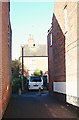
Chapel Lane, Arnold, Notts.
With Arnold's High Street a mere 2-3 minute walk away behind the photographer, this is the view towards the 'footpath only' section of Furlong Street. This lane is named after its association with a non-conformist chapel that previously existed at this end of this lane.
Image: © David Hallam-Jones
Taken: 15 Feb 2018
0.01 miles
2
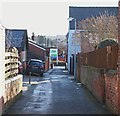
Chapel Lane, Arnold, Notts.
6-8 ft behind the photographer is a "bollard-ed" T junction that links to a footpath-only section of Furlong Street. This is the view towards Arnold's main shopping centre. A section of the High Street is situated beyond the wheelie bin in the distance. The name Chapel Lane derives from the existence of a (long-demolished) Wesleyan Methodist Chapel that was once situated behind the photographer.
Image: © David Hallam-Jones
Taken: 15 Feb 2018
0.01 miles
3
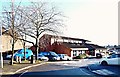
Stenhouse Medical Centre, Arnold, Notts.
This G.P. practice operates in a building constructed on some land that once belonged to the former "Pegasus and the Flying Horse" public house (now "Sprinters", a steak house). This is the view from the closed end of Furlong Street, a cul-de-sac. Arnold's High Street is a few metres ahead, at the far end of the health centre's car park, although it cannot be accessed through the car park.
Image: © David Hallam-Jones
Taken: 15 Feb 2018
0.03 miles
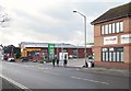
4
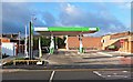
High Street, Arnold, Notts.
This newly opened petrol station (i.e. in December 2017) becomes Arnold's second such establishment. It occupies a site that previously hosted Arnold's police station. The police station finally closed in 2016 after less than a decade of service. A police contact point now exists within Gedling Borough Council's main office complex in Arnot Hill Park.
Image: © David Hallam-Jones
Taken: 28 Dec 2017
0.05 miles
5
High Street, Arnold, Notts.
Arnold's second petrol station opened in December 2017 and it occupies a site previously occupied by Arnold's police station. The station finally closed in 2016 after less than a decade of service. A police contact point now exists within Gedling Borough Council's main office complex in Arnot Hill Park. The stationary car is parked outside a Salvation Army Community Centre & Church, with Chapel Lane immediately beyond it.
Image: © David Hallam-Jones
Taken: 28 Dec 2017
0.06 miles
6
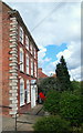
High Street, Arnold, Nottingham NG5
This Grade II-listed Georgian property known as "Bonington House" (a.k.a. 79, High Street) - is now the home of Arnold's Labour Club. It is apparently of early C18th construction. It was the birthplace of the English Romantic landscape painter Richard Parkes Bonington (1801-28). When he was 16 years old the Bonington family moved to Calais where his father had set up a lace factory. There he was tutored in English watercolour techniques by François L. T. Francia. In 1818, the family moved to Paris to open a lace shop and in 1820 Richard began attending the École des Beaux-Arts in Paris. Unfortunately he contracted tuberculosis at some point. This worsened in the mid-1820s and his parents sent him to London for treatment. However, he died of T.B in 1828 at 29, Tottenham Street at the age of 26 years of age. Houses on Bond Street are visible beyond this plot.
Image: © David Hallam-Jones
Taken: 23 Aug 2014
0.08 miles
7
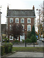
Bonington House
The birthplace of artist Richard Parkes Bonington [1], it's a fine mid-eighteenth century town house. He gives his name to the local theatre.
Image: © Alan Murray-Rust
Taken: 25 Oct 2009
0.08 miles
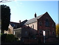
9
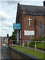
Church for sale
The former Cross Street Baptist Church.
Image: © Alan Murray-Rust
Taken: 12 Aug 2021
0.11 miles
10
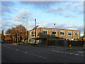
Arnold Health Centre
Conveniently sited in the town centre at the junction of Croft Road and High Street.
Image: © Alan Murray-Rust
Taken: 25 Oct 2009
0.11 miles