1
Acton Road, Arnold
Image: © JThomas
Taken: 9 Jan 2004
0.04 miles
2
Church Drive, Arnold, Notts.
In 1895 the Arnold School Board commissioned a school for the accommodation of 420 girls comprising a central hall and seven class rooms. The cost was £4,700 and this school was opened in November 1896. It became a senior school in 1908 and older girls who had until been attending a school in High Street began attending here. The architect, William H. Higginbottom, was born in Leeds in 1868 but before he was 1 year old the family moved to Arnold following his father, Anthony's, appointment as the Headmaster of the British School on the site now occupied by the Arnold market. Anthony, it seems, was also something of an amateur draughtsman and his interest prompted his son to study and qualify as an architect and surveyor. William eventually opened an architectural practice with offices at 120 Front street, Arnold and 2, Friar Yard, Friar Lane, Nottingham. Apparently William designed a good many of Arnold's other well-known buildings. Prior to its closure - and conversion into a Business Centre - it was a mixed Primary School. This is a view towards where Church Drive and Church Drive East form the top bar of a T shape, this being the shaft of the T.
Image: © David Hallam-Jones
Taken: 12 Jan 2014
0.07 miles
3
Church Drive, Arnold, Notts.
Before the junction with St Alban's Road (visible ahead) the northerly end of Church Drive becomes wider once past this former traditional Church or Chapel - currently "The Church of God Prophecy" (sic) - and the former Church Drive Primary School opposite it (and now a Business Centre). The year of construction of the church building is identifed above the entrance as 1900.
Image: © David Hallam-Jones
Taken: 12 Jan 2014
0.08 miles
4
High Street Avenue
General vehicle access from High Street is no longer permitted, although emergency and perhaps refuse collection vehicles can still make it over the moulded concrete blocks.
Image: © Alan Murray-Rust
Taken: 25 Oct 2009
0.09 miles
5
Furlong Street, Arnold, Notts.
A former Wesleyan Reform Church at the junction of Furlong Street and Burford Street. The latter, a cul-de-sac, lies on the other side of the church and leads - within minutes - to Arnold's High Street. This former church is identified on historical maps (c.1887) as a "Mission Room" or a 'Gospel Mission Room". It closed in 2016, affected by a dwindling congregation, and was sold at auction in 2017. Following its demolition the church is due to be replaced by a small number of terraced houses. On the left, signposted by a "School" road sign, is a Bestwood Avenue, a residential street that also hosts a secondary entrance into Arnold Mill Nursery and Primary School.
Image: © David Hallam-Jones
Taken: 15 Feb 2018
0.10 miles
6
Furlong Street, Arnold, Notts.
A former Wesleyan Reform Church at the junction of Furlong Street, on which several vans are parked, and Burford Street with a 'No Through Road' sign. This corner plot is identified on historical maps (c.1887) as boasting a "Mission Room" or a 'Gospel Mission Room". This latter day version of the church closed in 2016, affected by a dwindling congregation. It was sold at auction in 2017 and following its demolition the church is due to be replaced by a small number of terraced houses. High Street is a short walk away, at the eastern end of Burford Street, i.e. within 2-3 minutes.
Image: © David Hallam-Jones
Taken: 15 Feb 2018
0.10 miles
7
Burford Street, Arnold, Notts.
A former Wesleyan Reform Church at the junction of Burford Street and Furlong Street. Furlong Street runs from east to west in front of the tall semi-detached house ahead. This corner plot is identified on historical maps (c.1887) as boasting a "Mission Room" or a 'Gospel Mission Room". The church closed in 2016, affected by a dwindling congregation and was sold at auction in 2017. Following its demolition the church is due to be replaced by a small number of terraced houses. Arnold's High Street is a 2-3 minute walk away behind the photographer, whereas in the distance, a secondary entrance into Arnold Mill Nursery and Primary School can be reached at the far end of Bestwood Avenue.
Image: © David Hallam-Jones
Taken: 15 Feb 2018
0.11 miles
8
Church Drive, Arnold, Notts.
A number of the fairly substantial (4-5 bedroomed) Victorian semi-detached houses on Church Drive looking in the St Alban's Road direction. Interestingly, the housing stock on the other side of the road is a long - almost continuous - row of smaller terraced houses, presumably built later.
Image: © David Hallam-Jones
Taken: 12 Jan 2014
0.11 miles
9
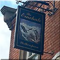
The sign of The Ernehale
Appears to depict a pair of bald eagles.
Image: © David Lally
Taken: 23 Aug 2018
0.12 miles
10
The Ernehale
Wetherspoons establishment.
Image: © David Lally
Taken: 23 Aug 2018
0.12 miles


