IMAGES TAKEN NEAR TO
Hallams Lane, NOTTINGHAM, NG5 6NE
Introduction
This page details the photographs taken nearby to Hallams Lane, NG5 6NE by members of the Geograph project.
The Geograph project started in 2005 with the aim of publishing, organising and preserving representative images for every square kilometre of Great Britain, Ireland and the Isle of Man.

There are currently over 7.5m images from over14,400 individuals and you can help contribute to the project by visiting https://www.geograph.org.uk
Image Map (Loading...)


Getting Data...Please wait
Leaflet Map data © OpenStreetMap
Images are licensed for reuse under creativecommons.org/licenses/by-sa/2.0
Notes
- Clicking on the map will re-center to the selected point.
- The higher the marker number, the further away the image location is from the centre of the postcode.
Image Listing (45 Images Found)
Images are licensed for reuse under creativecommons.org/licenses/by-sa/2.0
Image
Details
Distance
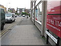
1
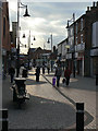
Front Street
The different textures of the pavement pick up a sudden burst of light through the clouds.
Image: © Alan Murray-Rust
Taken: 25 Oct 2009
0.04 miles
2

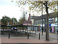
Gateway to King George V Recreation Ground
The gateway has been rebuilt in recent years, but incorporates the traditional memorial plaques associated with the George V playing fields scheme.
Image: © Alan Murray-Rust
Taken: 27 Jul 2016
0.04 miles
3
Arnold, The Market Place
As the notice indicates, the main open market is still held three times weekly, with additional weekly flea market and Trash & Treasure market.
The road name sign states 'The Market Place'.
Image: © Alan Murray-Rust
Taken: 25 Oct 2009
0.05 miles
4
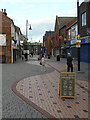
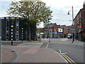
Pedestrianised Front Street
Looking north(ish) from the junction with High Street
Image: © Alan Murray-Rust
Taken: 25 Oct 2009
0.06 miles
6
Market Office
At Arnold Market; it may look a little forlorn, but this was a Sunday.
Image: © Alan Murray-Rust
Taken: 25 Oct 2009
0.07 miles
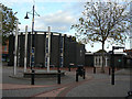
7
Pedestrianised Front Street
Surprisingly, High Street is not the main shopping street in Arnold, the accolade falling on Front Street. The southern section of the street is pedestrianised, seen here at the junction of Worrall Avenue. On the left is Arnold Methodist Church.
Image: © Alan Murray-Rust
Taken: 25 Oct 2009
0.07 miles
8
Arnold Methodist Church
On the corner of The Market Place and Front Street.
Image: © Alan Murray-Rust
Taken: 25 Oct 2009
0.07 miles
10
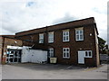
Former Drill Hall, Arnold, Nottingham (3)
Once a Drill Hall, used by the 8th Battalion, Sherwood Foresters, on Arnot Hill Road. Built about 1913, and now occupied by a firm of accountants, the building had accommodation for a caretaker sergeant, with a rifle range at the rear .A full description can be found at http://www.drillhalls.org/Counties/Nottinghamshire/Arnold.htm
Image: © Peter Barr
Taken: 21 Aug 2014
0.08 miles