IMAGES TAKEN NEAR TO
Carmel Gardens, NOTTINGHAM, NG5 6LZ
Introduction
This page details the photographs taken nearby to Carmel Gardens, NG5 6LZ by members of the Geograph project.
The Geograph project started in 2005 with the aim of publishing, organising and preserving representative images for every square kilometre of Great Britain, Ireland and the Isle of Man.

There are currently over 7.5m images from over14,400 individuals and you can help contribute to the project by visiting https://www.geograph.org.uk
Image Map
Images are licensed for reuse under creativecommons.org/licenses/by-sa/2.0
Notes
- Clicking on the map will re-center to the selected point.
- The higher the marker number, the further away the image location is from the centre of the postcode.
Image Listing (24 Images Found)
Images are licensed for reuse under creativecommons.org/licenses/by-sa/2.0
Image
Details
Distance
1
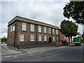
Former Drill Hall, Arnold, Nottingham
Once a Drill Hall, used by the 8th Battalion, Sherwood Foresters, on Arnot Hill Road. Built about 1913, and now occupied by a firm of accountants, the building had accommodation for a caretaker sergeant, with a rifle range at the rear .A full description can be found at http://www.drillhalls.org/Counties/Nottinghamshire/Arnold.htm
Image: © Peter Barr
Taken: 21 Aug 2014
0.18 miles
2
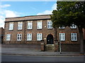
Former Drill Hall, Arnold, Nottingham (4)
Once a Drill Hall, used by the 8th Battalion, Sherwood Foresters, on Arnot Hill Road. Built about 1913, and now occupied by a firm of accountants, the building had accommodation for a caretaker sergeant, with a rifle range at the rear.
A full description can be found at http://www.drillhalls.org/Counties/Nottinghamshire/Arnold.htm
Image: © Peter Barr
Taken: 21 Aug 2014
0.18 miles
3
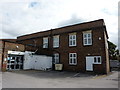
Former Drill Hall, Arnold, Nottingham (3)
Once a Drill Hall, used by the 8th Battalion, Sherwood Foresters, on Arnot Hill Road. Built about 1913, and now occupied by a firm of accountants, the building had accommodation for a caretaker sergeant, with a rifle range at the rear .A full description can be found at http://www.drillhalls.org/Counties/Nottinghamshire/Arnold.htm
Image: © Peter Barr
Taken: 21 Aug 2014
0.18 miles
4

Former Drill Hall, Arnold, Nottingham (2)
Once a Drill Hall, used by the 8th Battalion, Sherwood Foresters, on Arnot Hill Road. Built about 1913, and now occupied by a firm of accountants, the building had accommodation for a caretaker sergeant, with a rifle range at the rear.
This view shows the rifle range at the rear of the building.
A full description can be found at http://www.drillhalls.org/Counties/Nottinghamshire/Arnold.htm
Image: © Peter Barr
Taken: 21 Aug 2014
0.18 miles
5
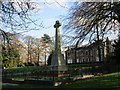
War memorial and Arnot Hill House
The war memorial stands in the park which goes with the house. http://www.britishlistedbuildings.co.uk/en-425306-arnot-hill-house-nottinghamshire#.VmXxRuKWMnA
Image: © Jonathan Thacker
Taken: 7 Dec 2015
0.21 miles
6
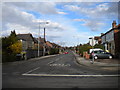
West end of Sandfield Road, Arnot Hill
Image: © Richard Vince
Taken: 22 Mar 2014
0.21 miles
7
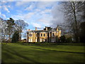
Arnot Hill House, Arnot Hill Park
Now used as office accommodation by Gedling Borough Council. For more information about its history, please see Image
Image: © Richard Vince
Taken: 22 Mar 2014
0.21 miles
8
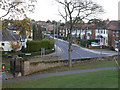
Sandfield Road, Arnold
Seen from the southern end of Arnot Hill Park
Image: © Alan Murray-Rust
Taken: 25 Oct 2009
0.22 miles
9

Arnot Hill Park, Arnold, Notts.
The Civic Centre, Arnot Hill House. Arnot Hill Park dates back to 1792. It originated as a landscaped estate to complement this house that was built by John Hawksley, a Nottingham mill owner and worsted manufacturer. Many changes have occurred since then to both the house and the grounds. In 1919 the park was formally opened as an open space for the people of Arnold.
Image: © David Hallam-Jones
Taken: 12 Jan 2014
0.22 miles
10
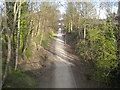
Former railway formation east of Thackeray's Lane, Arnot Hill
This footpath uses the formation of part of the "back line", the Great Northern Railway's route around the eastern and northern edges of Nottingham from Colwick towards Heanor and Derby. Here, the footpath passes under Thackeray's Lane towards the site of Daybrook Junction, where the later Nottingham Suburban Railway joined this line.
Image: © Richard Vince
Taken: 22 Mar 2014
0.22 miles