IMAGES TAKEN NEAR TO
Oxclose Lane, NOTTINGHAM, NG5 6FZ
Introduction
This page details the photographs taken nearby to Oxclose Lane, NG5 6FZ by members of the Geograph project.
The Geograph project started in 2005 with the aim of publishing, organising and preserving representative images for every square kilometre of Great Britain, Ireland and the Isle of Man.

There are currently over 7.5m images from over14,400 individuals and you can help contribute to the project by visiting https://www.geograph.org.uk
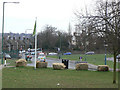
Image Map
Images are licensed for reuse under creativecommons.org/licenses/by-sa/2.0
Notes
- Clicking on the map will re-center to the selected point.
- The higher the marker number, the further away the image location is from the centre of the postcode.
Image Listing (33 Images Found)
Images are licensed for reuse under creativecommons.org/licenses/by-sa/2.0
Image
Details
Distance
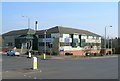
1
The Oxclose
A once popular pub serving the Bestwood estate. Now boarded up and looking forlorn.
Image: © Mick Garratt
Taken: 3 May 2008
0.00 miles
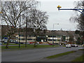
2
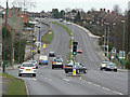
Oxclose Lane
East of Edwards Lane, the B6004 becomes Oxclose Lane and a dual carriageway. It is part of a major orbital route round north Nottingham.
Image: © Alan Murray-Rust
Taken: 15 Mar 2009
0.03 miles
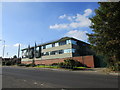
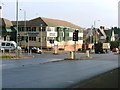
5
Oxclose Lane Police Station
Main Police centre for North Nottingham
Image: © Alan Murray-Rust
Taken: 15 Mar 2009
0.07 miles
7
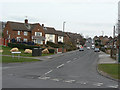
Chippenham Road
Part of the extensive Bestwood Park development from the 1950s onwards.
Image: © Alan Murray-Rust
Taken: 15 Mar 2009
0.08 miles
8
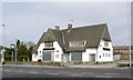
The top of Edwards Lane
Seen from Sandy Banks, looking south.
Image: © Alan Murray-Rust
Taken: 15 Mar 2009
0.09 miles
9
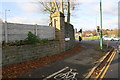
Edwards Lane at Arnold Road junction
There is an OS benchmark Image on the wall pier left of the road name sign
Image: © Roger Templeman
Taken: 29 Nov 2017
0.09 miles
10
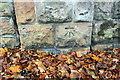
Benchmark on wall pier of Edwards Lane
Ordnance Survey cut mark benchmark described on the Bench Mark Database at http://www.bench-marks.org.uk/bm91947
Image: © Roger Templeman
Taken: 29 Nov 2017
0.10 miles