IMAGES TAKEN NEAR TO
Oxclose Lane, NOTTINGHAM, NG5 6FN
Introduction
This page details the photographs taken nearby to Oxclose Lane, NG5 6FN by members of the Geograph project.
The Geograph project started in 2005 with the aim of publishing, organising and preserving representative images for every square kilometre of Great Britain, Ireland and the Isle of Man.

There are currently over 7.5m images from over14,400 individuals and you can help contribute to the project by visiting https://www.geograph.org.uk
Image Map
Images are licensed for reuse under creativecommons.org/licenses/by-sa/2.0
Notes
- Clicking on the map will re-center to the selected point.
- The higher the marker number, the further away the image location is from the centre of the postcode.
Image Listing (13 Images Found)
Images are licensed for reuse under creativecommons.org/licenses/by-sa/2.0
Image
Details
Distance

2
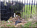
Boundary Marker, off Sherbrook Road
A scruffy view of the rear of one of the standard Nottingham cast-iron boundary markers. It is in a school playing field which makes it difficult to get to the front of it.
Image: © Alan Murray-Rust
Taken: 18 Mar 2014
0.08 miles
4
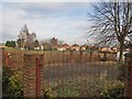
Site of former council housing off Rosecroft Drive
There were three blocks of maisonettes containing 36 dwellings (69-139 Rosecroft Drive) located here until around 2008.
The maisonettes are an unusual building type in the housing stock of Nottingham Borough Council. Existing examples are located on Abbey Bridge, Marchwood Close and Kibworth Court. I presume that the individual flats are single-aspect (i.e., back-to-back) given the size of the buildings, number of flats and doorways located on all sides of the building.
Image: © SK53
Taken: 4 Jan 2011
0.12 miles

6
Garages at the back of Sherbrook Road
It's clear that virtually none of these has seen any use for a long time.
Image: © Alan Murray-Rust
Taken: 18 Mar 2014
0.13 miles
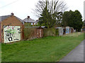
7
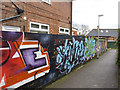
Brightening a dull wall
An instance of graffiti making a positive contribution.
Image: © Alan Murray-Rust
Taken: 18 Mar 2014
0.14 miles
8

Mosswood Crescent
Part of a large council development of the postwar period.
Image: © Alan Murray-Rust
Taken: 15 Mar 2009
0.17 miles
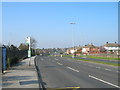
9
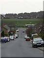
Chippenham Road
Looking down towards Edwards Lane.
Image: © Alan Murray-Rust
Taken: 15 Mar 2009
0.22 miles
10
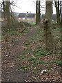
Woodland path on Glade Hill
Basically mature hardwoods. A solitary clump of crocuses adds a point of colour.
Image: © Alan Murray-Rust
Taken: 15 Mar 2009
0.23 miles