IMAGES TAKEN NEAR TO
Arnold Road, NOTTINGHAM, NG5 5XB
Introduction
This page details the photographs taken nearby to Arnold Road, NG5 5XB by members of the Geograph project.
The Geograph project started in 2005 with the aim of publishing, organising and preserving representative images for every square kilometre of Great Britain, Ireland and the Isle of Man.

There are currently over 7.5m images from over14,400 individuals and you can help contribute to the project by visiting https://www.geograph.org.uk
Image Map
Images are licensed for reuse under creativecommons.org/licenses/by-sa/2.0
Notes
- Clicking on the map will re-center to the selected point.
- The higher the marker number, the further away the image location is from the centre of the postcode.
Image Listing (65 Images Found)
Images are licensed for reuse under creativecommons.org/licenses/by-sa/2.0
Image
Details
Distance
1
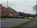
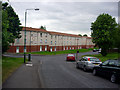
New housing on Arnold Lane
The land within the semicircle of Gainsford Crescent on the north side of Arnold Road has been developed for housing in the past few years. Previously the site was occupied by High Pavement College, resulting in the loss of a substantial area of potential open space and sports facilities.
Image: © Alan Murray-Rust
Taken: 15 Mar 2009
0.03 miles
2
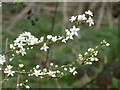
Flowering shrub alongside Arnold Road
Growing wild, a welcome sign of spring. Probably a species of Prunus.
Image: © Alan Murray-Rust
Taken: 15 Mar 2009
0.04 miles
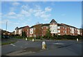
3
The Green Mews
"Keep out" housing development on Arnold Road.
Image: © Alan Murray-Rust
Taken: 15 Mar 2009
0.05 miles
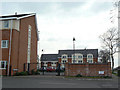
4
Apartments on the corner of Pavior Road
Image: © Jonathan Thacker
Taken: 15 Nov 2023
0.05 miles
5
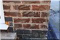
Benchmark on #314 Arnold Road
Ordnance Survey cut mark benchmark described on the Bench Mark Database at http://www.bench-marks.org.uk/bm91237
Image: © Roger Templeman
Taken: 29 Nov 2017
0.07 miles
6
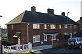
Row of houses on Arnold Road
There is an OS benchmark Image on the corner of the nearest house, right of its door
Image: © Roger Templeman
Taken: 29 Nov 2017
0.07 miles
7
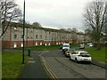
Belconnen Road
Recreating this 'First' for the square https://www.geograph.org.uk/photo/18538
Image: © Alan Murray-Rust
Taken: 8 Feb 2022
0.09 miles
8
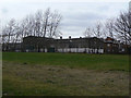
Factory off Arnold Road
This site was formerly occupied by a railway wagon works, the land in the foreground being the old Great Northern Railway line from Nottingham to Derby.
Image: © Alan Murray-Rust
Taken: 15 Mar 2009
0.09 miles
10
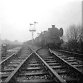
Leen Valley Junction: engines for scrap, 1965
Historical interest may compensate for the poor quality of this cropped scan of a small black-and-white print as nothing in this picture now exists.
The Great Northern Railway "Back Line" from Colwick to Basford and on to Derby had closed east of Daybrook on 4 April 1960, when Mapperley Tunnel was declared unsafe. Daybrook Station (a mile ahead) remained open for goods traffic until 1 June 1964, served from Basford North (a mile behind the camera). This picture was taken the winter after that, when the track and signals were still in place and the down siding was used to store withdrawn locomotives waiting to be cut up for scrap at Rigley's Wagon Works at Bulwell Forest (part of which is shown in Ben Brooksbank's Image]). A friend and I had come on an overcast winter afternoon to look at the impressive collection of Gresley O2 Class 2-8-0 heavy freight locomotives, the last of which had been withdrawn from service in 1963. The second engine in the line was a B1 4-6-0. Leen Valley Junction Signal Box was behind and to the right of where I stood. The taller signal in the centre of the picture had governed the main line to Basford and Derby, the lower one the Leen Valley route. Edwards Lane bridge is faintly visible in the distance, to the left of the line of engines. The houses of Belconnen Road and Wyton Close now occupy this site.
Image: © John Sutton
Taken: Unknown
0.10 miles