IMAGES TAKEN NEAR TO
Glade Hill Road, NOTTINGHAM, NG5 5SA
Introduction
This page details the photographs taken nearby to Glade Hill Road, NG5 5SA by members of the Geograph project.
The Geograph project started in 2005 with the aim of publishing, organising and preserving representative images for every square kilometre of Great Britain, Ireland and the Isle of Man.

There are currently over 7.5m images from over14,400 individuals and you can help contribute to the project by visiting https://www.geograph.org.uk
Image Map
Images are licensed for reuse under creativecommons.org/licenses/by-sa/2.0
Notes
- Clicking on the map will re-center to the selected point.
- The higher the marker number, the further away the image location is from the centre of the postcode.
Image Listing (13 Images Found)
Images are licensed for reuse under creativecommons.org/licenses/by-sa/2.0
Image
Details
Distance
1

Mosswood Crescent
Part of a large council development of the postwar period.
Image: © Alan Murray-Rust
Taken: 15 Mar 2009
0.11 miles
3

Mosswood Crescent Open Space
Primarily a small stand of mature hardwoods, with a small amount of open area and a rudimentary playground.
Image: © Alan Murray-Rust
Taken: 15 Mar 2009
0.14 miles
4
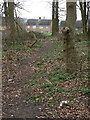
Woodland path on Glade Hill
Basically mature hardwoods. A solitary clump of crocuses adds a point of colour.
Image: © Alan Murray-Rust
Taken: 15 Mar 2009
0.15 miles
5
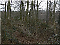
Woodland on Glade Hill
Known locally as "Bendigo's Ring", after the famous bare-knuckle boxer.
A little oasis of green entirely surrounded by housing. Mature hardwoods include Ash and Beech with a few Oak and Sweet Chestnut. The understory includes a number of young growth of these species too, rather than the more typical scrubbier trees such as thorn and elder.
Image: © Alan Murray-Rust
Taken: 15 Mar 2009
0.18 miles
6
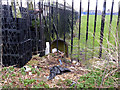
Boundary Marker, off Sherbrook Road
A scruffy view of the rear of one of the standard Nottingham cast-iron boundary markers. It is in a school playing field which makes it difficult to get to the front of it.
Image: © Alan Murray-Rust
Taken: 18 Mar 2014
0.20 miles
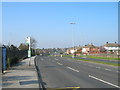
9
Chippenham Road
Looking down towards Edwards Lane.
Image: © Alan Murray-Rust
Taken: 15 Mar 2009
0.22 miles
10
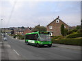
Bus ascending Chippenham Road
A 71 to Arnold climbs Chippenham Road in Bestwood Park estate.
Image: © Richard Vince
Taken: 3 Sep 2011
0.23 miles