IMAGES TAKEN NEAR TO
Snowdon Close, NOTTINGHAM, NG5 5QN
Introduction
This page details the photographs taken nearby to Snowdon Close, NG5 5QN by members of the Geograph project.
The Geograph project started in 2005 with the aim of publishing, organising and preserving representative images for every square kilometre of Great Britain, Ireland and the Isle of Man.

There are currently over 7.5m images from over14,400 individuals and you can help contribute to the project by visiting https://www.geograph.org.uk
Image Map
Images are licensed for reuse under creativecommons.org/licenses/by-sa/2.0
Notes
- Clicking on the map will re-center to the selected point.
- The higher the marker number, the further away the image location is from the centre of the postcode.
Image Listing (31 Images Found)
Images are licensed for reuse under creativecommons.org/licenses/by-sa/2.0
Image
Details
Distance
1
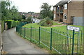
Evedon Walk
Maisonette block at the northern end of Bestwood Park estate.
Image: © Alan Murray-Rust
Taken: 20 Jul 2010
0.06 miles
2
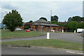
The Duke of St Albans
Modern public house at the junction of Bestwood Park Drive and Bewcastle Road. The name derives from the owners of the adjacent Bestwood Lodge.
Image: © Alan Murray-Rust
Taken: 20 Jul 2010
0.08 miles
3
Duke of St Albans, Bewcastle Road, Nottingham
Image: © JThomas
Taken: 16 Apr 2010
0.08 miles
4
Treegarth Square
The northern end of the Bestwood Park estate, a small group of houses filling the space between Bestwood Park Drive and the city boundary.
Image: © Alan Murray-Rust
Taken: 20 Jul 2010
0.10 miles
5
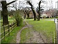
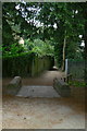
Pedestrian Shortcut into the Bestwood Lodge Woods
Image: © Mick Garratt
Taken: 22 Apr 2006
0.15 miles
7
Ridgeway or Ridge Way
Road name signs have been inconsistent over the years as to whether it should be one word or two.
Image: © Alan Murray-Rust
Taken: 20 Jul 2010
0.16 miles
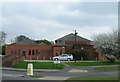
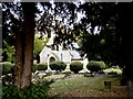
8
Emmanuel Church, Warren Hill - Dedication Plaque
Image: © Oxymoron
Taken: 12 Nov 2008
0.17 miles
9
Former lych gate, Emmanuel Church
The original site at the east end of the churchyard.
On another website a 'Local parishioner' writes:
"The lychgate has recently (2009) been relocated to the other side of the church yard. This was done in order that it might be saved from destruction through repeated acts of vandalism. The stone walls remain in position but the steps have recently been covered over by a ramp. The relocated wooden structure has been resited on new stone work. The original location had been the main entrance into the church yard but had fallen into disuse due to modern housing developments surrounding the church. The new location means that the lychgate functions once again as it was intended.
I believe that English heritage have lost interest in it being a listed structure now that it has been moved."
The lych gate can be seen in its new location in http://www.geograph.org.uk/photo/2005013 .
Image: © Alan Murray-Rust
Taken: 20 Jul 2010
0.17 miles
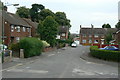
10
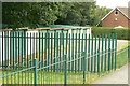
Lock-up garages
On Queens Bower Road. Bestwood Park Estate was developed at a time when it was not considered necessary to provide garages with every dwelling.
Image: © Alan Murray-Rust
Taken: 20 Jul 2010
0.17 miles