IMAGES TAKEN NEAR TO
Rose Ash Lane, NOTTINGHAM, NG5 5PZ
Introduction
This page details the photographs taken nearby to Rose Ash Lane, NG5 5PZ by members of the Geograph project.
The Geograph project started in 2005 with the aim of publishing, organising and preserving representative images for every square kilometre of Great Britain, Ireland and the Isle of Man.

There are currently over 7.5m images from over14,400 individuals and you can help contribute to the project by visiting https://www.geograph.org.uk
Image Map
Images are licensed for reuse under creativecommons.org/licenses/by-sa/2.0
Notes
- Clicking on the map will re-center to the selected point.
- The higher the marker number, the further away the image location is from the centre of the postcode.
Image Listing (12 Images Found)
Images are licensed for reuse under creativecommons.org/licenses/by-sa/2.0
Image
Details
Distance
2
Lock-up garages
On Queens Bower Road. Bestwood Park Estate was developed at a time when it was not considered necessary to provide garages with every dwelling.
Image: © Alan Murray-Rust
Taken: 20 Jul 2010
0.11 miles
4
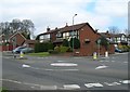
Deer Park Drive
The junction with Queens Bower Road, looking across to the earlier Bestwood Park Estate.
Image: © Alan Murray-Rust
Taken: 20 Jul 2010
0.12 miles
5
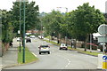
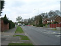
Bestwood Park Drive
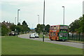
Looking south east from Deer Park Drive. this is part of an important orbital route round the north of Nottingham, linking Bulwell with Arnold.
Image: © Alan Murray-Rust
Taken: 20 Jul 2010
0.12 miles
6
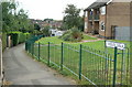
Evedon Walk
Maisonette block at the northern end of Bestwood Park estate.
Image: © Alan Murray-Rust
Taken: 20 Jul 2010
0.16 miles
7
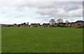
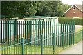
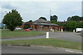
Recreation ground, Robin Hood Road
This is formally part of Bestwood Country Park.
Image: © Alan Murray-Rust
Taken: 18 Mar 2014
0.17 miles
8
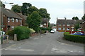
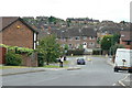
Treegarth Square
The northern end of the Bestwood Park estate, a small group of houses filling the space between Bestwood Park Drive and the city boundary.
Image: © Alan Murray-Rust
Taken: 20 Jul 2010
0.18 miles
9
Ridgeway or Ridge Way
Road name signs have been inconsistent over the years as to whether it should be one word or two.
Image: © Alan Murray-Rust
Taken: 20 Jul 2010
0.20 miles
10
The Duke of St Albans
Modern public house at the junction of Bestwood Park Drive and Bewcastle Road. The name derives from the owners of the adjacent Bestwood Lodge.
Image: © Alan Murray-Rust
Taken: 20 Jul 2010
0.23 miles