IMAGES TAKEN NEAR TO
Leahy Gardens, NOTTINGHAM, NG5 5LS
Introduction
This page details the photographs taken nearby to Leahy Gardens, NG5 5LS by members of the Geograph project.
The Geograph project started in 2005 with the aim of publishing, organising and preserving representative images for every square kilometre of Great Britain, Ireland and the Isle of Man.

There are currently over 7.5m images from over14,400 individuals and you can help contribute to the project by visiting https://www.geograph.org.uk
Image Map
Images are licensed for reuse under creativecommons.org/licenses/by-sa/2.0
Notes
- Clicking on the map will re-center to the selected point.
- The higher the marker number, the further away the image location is from the centre of the postcode.
Image Listing (34 Images Found)
Images are licensed for reuse under creativecommons.org/licenses/by-sa/2.0
Image
Details
Distance
1
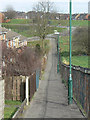
Footpath at the back of Ellsworth Drive
Part of the 1980s development of Bestwood Estate.
Image: © Alan Murray-Rust
Taken: 15 Mar 2009
0.07 miles
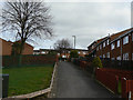
2
In Bestwood Estate
Meeting point of several pedestrian ways in the eastwards extension of Bestwood Estate from the 1980s. The visible houses belong to several different addresses.
Image: © Alan Murray-Rust
Taken: 15 Mar 2009
0.07 miles
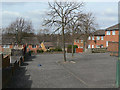
3
Former Padstow School grounds
The school was closed during a major reconstruction of education in Nottingham, and the former grounds are now accessible as open space.
Image: © Alan Murray-Rust
Taken: 15 Mar 2009
0.07 miles
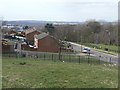
4
Turning head at Ellsworth Rise
The road runs at the back of the houses which have pedestrian access to their fronts.
Image: © Alan Murray-Rust
Taken: 15 Mar 2009
0.08 miles
5
Barent Walk
1980s housing on Bestwood Estate - a network of pedestrian access to the fronts of houses, vehicle access at the back.
Image: © Alan Murray-Rust
Taken: 15 Mar 2009
0.08 miles
6
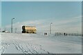
Bus on Parkview Road – 1982
Sunshine following a substantial snowfall.
The bus is City of Nottingham Transport 666, a Leyland Atlantean with Northern Counties bodywork, new in 1978. The body was designed as a new version of the standard Nottingham style https://www.geograph.org.uk/photo/7545914 with several new features, but remained a one-off.
This is one of a series of views featuring buses in the 60s, 70s, and 80s. http://www.geograph.org.uk/search.php?i=137652761
Image: © Alan Murray-Rust
Taken: 11 Jan 1982
0.09 miles
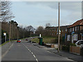
7

Parkview Drive
Although consistently shown on maps as Parkview Road, the road name sign shows Parview Drive!
Image: © Alan Murray-Rust
Taken: 15 Mar 2009
0.10 miles
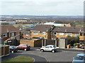
8
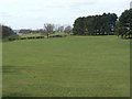
Southglade Park
Looking west from Parkview Drive
Image: © Alan Murray-Rust
Taken: 15 Mar 2009
0.11 miles
9
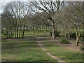
Woodland glade
In Southglade Park, developed from former farmland.
Image: © Alan Murray-Rust
Taken: 15 Mar 2009
0.11 miles
10
Southglade Road
Until around 1980 the road ended here, as can be seen by the style of housing beyond the building to the right.
Image: © Alan Murray-Rust
Taken: 15 Mar 2009
0.11 miles