IMAGES TAKEN NEAR TO
Mountfield Drive, NOTTINGHAM, NG5 5LH
Introduction
This page details the photographs taken nearby to Mountfield Drive, NG5 5LH by members of the Geograph project.
The Geograph project started in 2005 with the aim of publishing, organising and preserving representative images for every square kilometre of Great Britain, Ireland and the Isle of Man.

There are currently over 7.5m images from over14,400 individuals and you can help contribute to the project by visiting https://www.geograph.org.uk
Image Map
Images are licensed for reuse under creativecommons.org/licenses/by-sa/2.0
Notes
- Clicking on the map will re-center to the selected point.
- The higher the marker number, the further away the image location is from the centre of the postcode.
Image Listing (26 Images Found)
Images are licensed for reuse under creativecommons.org/licenses/by-sa/2.0
Image
Details
Distance
1
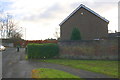
#1 Pedmore Valley
There is an OS benchmark Image on the brick wall about 18 inches from its junction with the hedge
Image: © Roger Templeman
Taken: 29 Nov 2017
0.09 miles
2
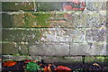
Benchmark on wall bounding #1 Pedmore Valley
Ordnance Survey cut mark benchmark described on the Bench Mark Database at http://www.bench-marks.org.uk/bm91946
Image: © Roger Templeman
Taken: 29 Nov 2017
0.09 miles
3

Benchmark on wall of Beckhampton Road
Ordnance Survey cut mark benchmark described on the Bench Mark Database at http://www.bench-marks.org.uk/bm91945
Image: © Roger Templeman
Taken: 29 Nov 2017
0.10 miles
4
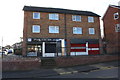
Tattoo studio, Beckhampton Road at Hartcroft Road junction
There is an OS benchmark Image on the roadside wall left of the steps
Image: © Roger Templeman
Taken: 29 Nov 2017
0.11 miles
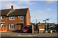
5
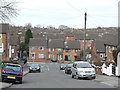
Hartcroft Road
Looking down to Beckhampton Road. The southern end of the postwar Bestwood Park Estate.
Image: © Alan Murray-Rust
Taken: 15 Mar 2009
0.11 miles
6
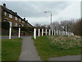
Chiltern Way
Housing on the edge of Sandy Banks Nature Reserve. The reserve survives despite being a major pedestrian route with no particular protection for the vegetation.
For more about the reserve, see Image
Image: © Alan Murray-Rust
Taken: 15 Mar 2009
0.13 miles
7
#84 Beckhampton Road
Ordnance Survey documents indicate that a benchmark levelled at 92.702m above Newlyn Datum was verified on the side of the house at its front corner
Image: © Roger Templeman
Taken: 29 Nov 2017
0.15 miles
8
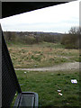
Sandy Banks Nature Reserve
Looking down the site from the shelter at the top. In the foreground is a rough track for ATB cyclists.
Image: © Alan Murray-Rust
Taken: 15 Mar 2009
0.15 miles
9
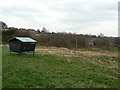
Sandy Banks Nature Reserve
The reserve has to double as a local recreational area, including a portion set out as a small rough bike track. The shelter appears to have been provided as part of this.
For more about the reserve, see Image
Image: © Alan Murray-Rust
Taken: 15 Mar 2009
0.16 miles
10
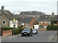
Stevenholme Crescent at Hartcroft Road
The trees on the skyline are on Glade Hill
Image: © Alan Murray-Rust
Taken: 15 Mar 2009
0.16 miles