IMAGES TAKEN NEAR TO
Arnold Road, NOTTINGHAM, NG5 5HL
Introduction
This page details the photographs taken nearby to Arnold Road, NG5 5HL by members of the Geograph project.
The Geograph project started in 2005 with the aim of publishing, organising and preserving representative images for every square kilometre of Great Britain, Ireland and the Isle of Man.

There are currently over 7.5m images from over14,400 individuals and you can help contribute to the project by visiting https://www.geograph.org.uk
Image Map
Images are licensed for reuse under creativecommons.org/licenses/by-sa/2.0
Notes
- Clicking on the map will re-center to the selected point.
- The higher the marker number, the further away the image location is from the centre of the postcode.
Image Listing (46 Images Found)
Images are licensed for reuse under creativecommons.org/licenses/by-sa/2.0
Image
Details
Distance
1
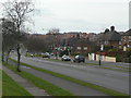
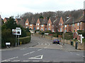
Arnold Road
Clearly conceived as a major orbital road, with dedicated service roads, cycleways and footways on both sides of the carriageway. It is still essentially an outer ring road for Nottingham.
Image: © Alan Murray-Rust
Taken: 15 Mar 2009
0.03 miles
2
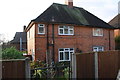
Nos. 3 & 5 Landcroft Crescent
There is an OS benchmark Image on the front of the left hand house near its front left corner, behind a hydrangea bush
Image: © Roger Templeman
Taken: 29 Nov 2017
0.06 miles
3
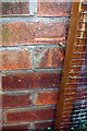
Benchmark on #3 Landcroft Crescent
Ordnance Survey cut mark benchmark described on the Bench Mark Database at http://www.bench-marks.org.uk/bm91948
Image: © Roger Templeman
Taken: 29 Nov 2017
0.06 miles
4
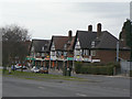
Shops on Arnold Road
Typical late 1930s Tudorbethan style.
Image: © Alan Murray-Rust
Taken: 15 Mar 2009
0.06 miles
5
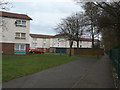
Landcroft Crescent
The eastern end of Bestwood Estate, nestling under Sunrise Hill.
Image: © Alan Murray-Rust
Taken: 15 Mar 2009
0.07 miles
6
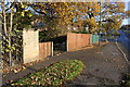
Pavement of Arnold Road approaching Gainsford Crescent junction
There is an OS benchmark Image on the short stone wall section at the left hand side of the image
Image: © Roger Templeman
Taken: 29 Nov 2017
0.11 miles
7
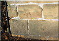
Benchmark on Arnold Road wall near Gainsford Crescent junction
Ordnance Survey cut mark benchmark described on the Bench Mark Database at http://www.bench-marks.org.uk/bm91704
Image: © Roger Templeman
Taken: 29 Nov 2017
0.12 miles
8
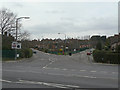
Gainsford Crescent
The east junction of Gainsford Crescent with Arnold Road is complicated by the presence of Carnwood Road. This used to run straight down as can be seen by the old pavement line.
Image: © Alan Murray-Rust
Taken: 15 Mar 2009
0.12 miles
9
Flats at Wyton Close
I believe these were built as accommodation for staff at the neighbouring City Hospital.
Image: © Alan Murray-Rust
Taken: 15 Mar 2009
0.13 miles
10
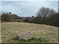
Sunrise Hill looking east
The choice of the location for a triangulation point is clear, despite the existence of houses.
Image: © Alan Murray-Rust
Taken: 15 Mar 2009
0.13 miles