IMAGES TAKEN NEAR TO
Gainsford Crescent, NOTTINGHAM, NG5 5FJ
Introduction
This page details the photographs taken nearby to Gainsford Crescent, NG5 5FJ by members of the Geograph project.
The Geograph project started in 2005 with the aim of publishing, organising and preserving representative images for every square kilometre of Great Britain, Ireland and the Isle of Man.

There are currently over 7.5m images from over14,400 individuals and you can help contribute to the project by visiting https://www.geograph.org.uk
Image Map
Images are licensed for reuse under creativecommons.org/licenses/by-sa/2.0
Notes
- Clicking on the map will re-center to the selected point.
- The higher the marker number, the further away the image location is from the centre of the postcode.
Image Listing (34 Images Found)
Images are licensed for reuse under creativecommons.org/licenses/by-sa/2.0
Image
Details
Distance
1

Henry Whipple School
Primary School serving Bestwood Estate.
Image: © Alan Murray-Rust
Taken: 15 Mar 2009
0.08 miles
2
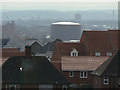
View from Bestwood Estate
From the old Padstow School site. The nearest houses with the hipped roofs are on Gainsford Crescent and date from the late 1930s. Next beyond them is the recent estate which replaced the former High Pavement College. Beyond can be seen one of the Baford gasometers, to its left the former Shipstones brewery, beyond it the Engineering Department tower at the university of Nottingham.
Image: © Alan Murray-Rust
Taken: 15 Mar 2009
0.09 miles
3
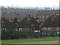
View from near Sunrise Hill
The older houses in the foreground are on Gainsford Crescent, behind them the new housing development on the former High Pavement College site, and in the distance Radford (left) and Basford (centre right).
Image: © Alan Murray-Rust
Taken: 15 Mar 2009
0.13 miles
4
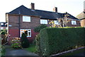
#154 Gainsford Crescent
There is an OS benchmark Image on the left hand side of the house near its front corner beside steps to door
Image: © Roger Templeman
Taken: 29 Nov 2017
0.15 miles
5
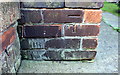
Benchmark on #154 Gainsborough Crescent
Ordnance Survey cut mark benchmark described on the Bench Mark Database at http://www.bench-marks.org.uk/bm91705
Image: © Roger Templeman
Taken: 29 Nov 2017
0.16 miles
6

Sunrise Hill
Looking west from the trig point, sadly now toppled.
Image: © Alan Murray-Rust
Taken: 15 Mar 2009
0.16 miles
7
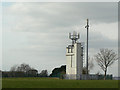
Communications tower
The tower appears to be the last remaining part of the former Padstow School, presumably its water supply, and has survived due to its use as a communications mast.
Image: © Alan Murray-Rust
Taken: 15 Mar 2009
0.17 miles
8
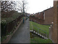
Footpath at the back of Peary Close
In the 1980s-developed part of Bestwood Estate.
Image: © Alan Murray-Rust
Taken: 15 Mar 2009
0.18 miles
9
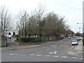
Gainsford Crescent junction
The western junction with Arnold Road. Andover Road (left) used to come straight out at this junction which has been substantially re-modelled to improve traffic flows.
Image: © Alan Murray-Rust
Taken: 15 Mar 2009
0.19 miles
10
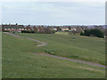
Former Padstow School site
Now accessible as open space. Virtually all sign of the former buildings has disappeared - I needed to refer to an old street map to find out what had been here!
Image: © Alan Murray-Rust
Taken: 15 Mar 2009
0.19 miles