IMAGES TAKEN NEAR TO
Shaldon Close, NOTTINGHAM, NG5 5EN
Introduction
This page details the photographs taken nearby to Shaldon Close, NG5 5EN by members of the Geograph project.
The Geograph project started in 2005 with the aim of publishing, organising and preserving representative images for every square kilometre of Great Britain, Ireland and the Isle of Man.

There are currently over 7.5m images from over14,400 individuals and you can help contribute to the project by visiting https://www.geograph.org.uk
Image Map
Images are licensed for reuse under creativecommons.org/licenses/by-sa/2.0
Notes
- Clicking on the map will re-center to the selected point.
- The higher the marker number, the further away the image location is from the centre of the postcode.
Image Listing (40 Images Found)
Images are licensed for reuse under creativecommons.org/licenses/by-sa/2.0
Image
Details
Distance
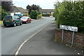
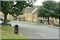
2
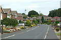
Bracadale Road
The most easterly road in Rise Park Estate. Road names here are associated with the Isle of Skye.
Image: © Alan Murray-Rust
Taken: 20 Jul 2010
0.06 miles
3
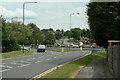
Roundabout on Bestwood Park Drive
At the junction with Top Valley Way and Muirfield Road.
Image: © Alan Murray-Rust
Taken: 20 Jul 2010
0.06 miles
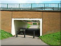
5
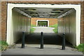
Double subway
Through the roundabout at the junction of Bestwood Park Drive and Top Valley Way http://www.geograph.org.uk/photo/2004908.
Image: © Alan Murray-Rust
Taken: 20 Jul 2010
0.07 miles
6
Leading to Bracadale Road
This short section of road has no houses actually facing on to it, and appears to have no formal name. Adjacent houses belong either to Bracadale Road or to Dunvegan Drive.
Image: © Alan Murray-Rust
Taken: 20 Jul 2010
0.08 miles
7
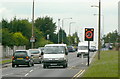
Temporary speed limit
Operating at school opening and closing times and incorporating a patrolled crossing.
Image: © Alan Murray-Rust
Taken: 20 Jul 2010
0.09 miles
8
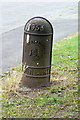
City of Nottingham boundary marker
On Lytham Gardens, this was originally in a completely rural location on a field boundary, but survived the area's development as a housing estate http://www.geograph.org.uk/photo/2004929.
1933 marked a major change to the boundary of the city when significant areas were transferred from neighbouring local authorities.
Image: © Alan Murray-Rust
Taken: 20 Jul 2010
0.09 miles
9
Lytham Gardens
Part of a development of public sector housing by Nottingham City Council which crossed the City boundary into Ashfield District. The cast iron object is a typical Nottingham boundary post, seen in detail in http://www.geograph.org.uk/photo/2004940 .
Image: © Alan Murray-Rust
Taken: 20 Jul 2010
0.09 miles
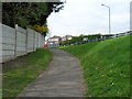
10
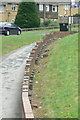
Subway wall
This retaining wall alongside a footpath leading down to a pedestrian subway is in need of some remedial attention.
Image: © Alan Murray-Rust
Taken: 20 Jul 2010
0.10 miles