IMAGES TAKEN NEAR TO
Bestwood Park Drive West, NOTTINGHAM, NG5 5EJ
Introduction
This page details the photographs taken nearby to Bestwood Park Drive West, NG5 5EJ by members of the Geograph project.
The Geograph project started in 2005 with the aim of publishing, organising and preserving representative images for every square kilometre of Great Britain, Ireland and the Isle of Man.

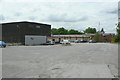
There are currently over 7.5m images from over14,400 individuals and you can help contribute to the project by visiting https://www.geograph.org.uk
Image Map
Images are licensed for reuse under creativecommons.org/licenses/by-sa/2.0
Notes
- Clicking on the map will re-center to the selected point.
- The higher the marker number, the further away the image location is from the centre of the postcode.
Image Listing (31 Images Found)
Images are licensed for reuse under creativecommons.org/licenses/by-sa/2.0
Image
Details
Distance
1
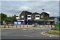
Rise Park shops
The left hand unit includes the local Post Office.
Image: © Alan Murray-Rust
Taken: 20 Jul 2010
0.01 miles
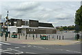
2
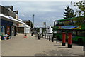
Rise Park bus terminus
Sited at the local shopping centre, which includes the local Post Office, for which a pair of pillar boxes has been provided. Ref Nos: NG5 108 and NG5 109.
Image: © Alan Murray-Rust
Taken: 20 Jul 2010
0.01 miles
3
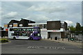
The old Charlie Two
The right hand building is the former Charles II public house, soon to reopen as a small supermarket.
Image: © Alan Murray-Rust
Taken: 20 Jul 2010
0.01 miles
4
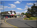
Bus turning circle, Rise Park
Rise Park's small district centre is provided with a large bus turning circle that contains four bus stops (the fourth being hidden from view by the trees on the right). At the time of posting only two bus routes normally terminate here (the 16 and 89, to Nottingham city centre via Hucknall Road and Edwards Lane respectively), the other two stops being used by routes 79 and 79A (to Arnold in one direction and to the city centre via Bulwell in the other). The convenience store at the far end of the turning circle (centre) was formerly a somewhat infamous pub called the Charles II, presumably named in deference to the gift of land in this area by that monarch to his mistress, Nell Gwynne.
Image: © Richard Vince
Taken: 27 May 2013
0.02 miles
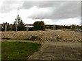
5
Car Park at Rise Park
Serving the small retail development on Bestwood Park Drive. This was originally much larger, but the former retail units in the background have since been converted.
Image: © Alan Murray-Rust
Taken: 20 Jul 2010
0.02 miles
6
Spar Park
Car park at Rise Park awaiting the opening of a new Spar supermarket. The building was formerly the Charles II public house, and the light patches of brickwork on the first floor indicate where the pub signs used to be.
Image: © Alan Murray-Rust
Taken: 20 Jul 2010
0.03 miles
8
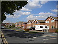
Houses on Brownlow Drive, Rise Park
These rather plain looking detached houses are fairly typical of Rise Park, a suburban development which was somewhat isolated from the rest of Nottingham until Top Valley estate was developed to the south, filling the gap between Rise Park and Bestwood Park.
Image: © Richard Vince
Taken: 27 May 2013
0.05 miles
9
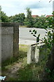
Bench mark at Brownlow Drive
Best seen in the high resolution version, the bench mark is on the brickwork of what appears to be a disused electricity substation.
Image: © Alan Murray-Rust
Taken: 20 Jul 2010
0.05 miles
10

Academy Day Nursery
Built on the site of a petrol filling station.
Image: © Alan Murray-Rust
Taken: 20 Jul 2010
0.05 miles