IMAGES TAKEN NEAR TO
Revelstoke Way, NOTTINGHAM, NG5 5AH
Introduction
This page details the photographs taken nearby to Revelstoke Way, NG5 5AH by members of the Geograph project.
The Geograph project started in 2005 with the aim of publishing, organising and preserving representative images for every square kilometre of Great Britain, Ireland and the Isle of Man.

There are currently over 7.5m images from over14,400 individuals and you can help contribute to the project by visiting https://www.geograph.org.uk
Image Map
Images are licensed for reuse under creativecommons.org/licenses/by-sa/2.0
Notes
- Clicking on the map will re-center to the selected point.
- The higher the marker number, the further away the image location is from the centre of the postcode.
Image Listing (32 Images Found)
Images are licensed for reuse under creativecommons.org/licenses/by-sa/2.0
Image
Details
Distance
1
Colinwood Avenue
Looking across to the southern part of Rise Park.
Image: © Alan Murray-Rust
Taken: 20 Jul 2010
0.04 miles
2
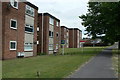
Oulton and Burnham Lodges
A small group of flat blocks in the Rise Park Estate.
Image: © Alan Murray-Rust
Taken: 20 Jul 2010
0.08 miles
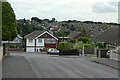
3
Crowthorne Close
Typical road in the Rise Park Estate.
Image: © Alan Murray-Rust
Taken: 20 Jul 2010
0.11 miles
4
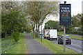
Speed indicator on Bestwood Park Drive West
Image: © David Lally
Taken: 27 Apr 2017
0.12 miles
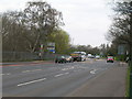
5
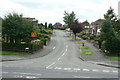
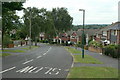
Rise Park Road
The western junction with Bestwood Park Drive West.
Image: © Alan Murray-Rust
Taken: 20 Jul 2010
0.14 miles
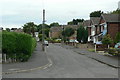
8
Brownlow Drive
This is the main distributor road in the northern section of Rise Park Estate. Looking west at Haverhill Crescent
Image: © Alan Murray-Rust
Taken: 20 Jul 2010
0.15 miles
9
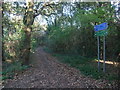
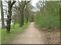
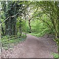
Cycle Route 6 leading towards Bestwood Park
Image: © Tim Heaton
Taken: 11 Nov 2012
0.16 miles