IMAGES TAKEN NEAR TO
Littlegreen Road, NOTTINGHAM, NG5 4LP
Introduction
This page details the photographs taken nearby to Littlegreen Road, NG5 4LP by members of the Geograph project.
The Geograph project started in 2005 with the aim of publishing, organising and preserving representative images for every square kilometre of Great Britain, Ireland and the Isle of Man.

There are currently over 7.5m images from over14,400 individuals and you can help contribute to the project by visiting https://www.geograph.org.uk
Image Map
Images are licensed for reuse under creativecommons.org/licenses/by-sa/2.0
Notes
- Clicking on the map will re-center to the selected point.
- The higher the marker number, the further away the image location is from the centre of the postcode.
Image Listing (14 Images Found)
Images are licensed for reuse under creativecommons.org/licenses/by-sa/2.0
Image
Details
Distance
1
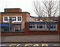
Somersby Road, Arnold, Notts.
Situated on the east side of the northern end of Somersby Road. The Good Shepherd Primary School looks as though it has here for a good many years and only its new, blue, name board - advertising its change of status in 2012 to that of an academy - indicates this important change to passers-by. The school is sponsored by the Pax Christi Catholic Academy Trust.
Image: © David Hallam-Jones
Taken: 1 Jan 2016
0.11 miles
2
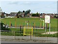
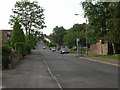
Arno Vale Recreation Ground
Open space alongside Arno Vale Road.
Image: © Alan Murray-Rust
Taken: 12 Aug 2021
0.12 miles
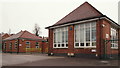
3
Be Kind, Be Brave, Be Happy . . .
. . . is the message on Woodthorpe Infant School.
Image: © Alan Murray-Rust
Taken: 12 Aug 2021
0.14 miles
5
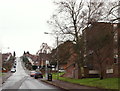
Somersby Road
This gets very steep towards the end - the picture doesn't really do it justice.
Image: © Oxymoron
Taken: 25 Jul 2008
0.17 miles
6
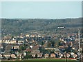
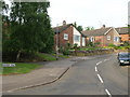
Somersby road
View as seen from the top of the hill at Somersby Road
Image: © Neil Packwood
Taken: 18 Jan 2009
0.17 miles
7
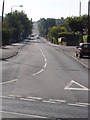
Somersby Road, Arnold, Notts.
With approximately 25% of the overall length of Somersby Road behind the photographer, this is a view of the southern-facing 75% of it, looking in the direction of Mapperley. Its junction with Plains Road, Mapperley, (the B684 Nottingham centre - Dorket Head road) is over the brow of the hill. Behind the bus stop a parade of shops serves the locality.
Image: © David Hallam-Jones
Taken: 1 Jan 2016
0.17 miles
9
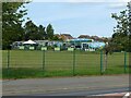
Savile Road, Arnold, Notts.
This is part of Arnot Hill Primary School, seen from the school gates.
Image: © David Hallam-Jones
Taken: 1 Jan 2016
0.18 miles
10
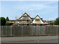
Removing the render
Sunnyhome is the last remaining house in the immediate locality which survives from before the development of Arno Vale Road and the housing visible in the background in the second half of the 20th century.
Image: © Alan Murray-Rust
Taken: 12 Aug 2021
0.19 miles