IMAGES TAKEN NEAR TO
Patterdale Road, NOTTINGHAM, NG5 4LF
Introduction
This page details the photographs taken nearby to Patterdale Road, NG5 4LF by members of the Geograph project.
The Geograph project started in 2005 with the aim of publishing, organising and preserving representative images for every square kilometre of Great Britain, Ireland and the Isle of Man.

There are currently over 7.5m images from over14,400 individuals and you can help contribute to the project by visiting https://www.geograph.org.uk
Image Map
Images are licensed for reuse under creativecommons.org/licenses/by-sa/2.0
Notes
- Clicking on the map will re-center to the selected point.
- The higher the marker number, the further away the image location is from the centre of the postcode.
Image Listing (14 Images Found)
Images are licensed for reuse under creativecommons.org/licenses/by-sa/2.0
Image
Details
Distance
1
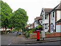
Woodthorpe: Whernside Road
A leafy 1930s suburb on a May evening.
Image: © John Sutton
Taken: 12 May 2014
0.09 miles
2

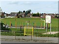
Savile Road, Arnold, Notts.
This is part of Arnot Hill Primary School, seen from the school gates.
Image: © David Hallam-Jones
Taken: 1 Jan 2016
0.12 miles
3

Arnold - the NE fringe of Nottingham
Seen from the air over Sherwood, looking northeast towards Woodborough. The pale patch in the forest towards top right is HM Prison Lowdham Grange.
Image: © M J Richardson
Taken: 5 Apr 2016
0.14 miles

5
Be Kind, Be Brave, Be Happy . . .
. . . is the message on Woodthorpe Infant School.
Image: © Alan Murray-Rust
Taken: 12 Aug 2021
0.19 miles
6
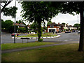
Five ways
Roundabout at junction of Thackerays Lane and Arno Vale Road.
Image: © Q
Taken: 14 Jun 2005
0.19 miles
7

Five ways
Recreating this 'First' for the square http://www.geograph.org.uk/photo/18589
Image: © Alan Murray-Rust
Taken: 12 Aug 2021
0.19 miles
8
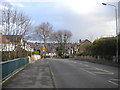
North east end of Thackeray's Lane, Arnot Hill
Image: © Richard Vince
Taken: 22 Mar 2014
0.22 miles
9
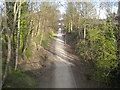
Former railway formation east of Thackeray's Lane, Arnot Hill
This footpath uses the formation of part of the "back line", the Great Northern Railway's route around the eastern and northern edges of Nottingham from Colwick towards Heanor and Derby. Here, the footpath passes under Thackeray's Lane towards the site of Daybrook Junction, where the later Nottingham Suburban Railway joined this line.
Image: © Richard Vince
Taken: 22 Mar 2014
0.23 miles
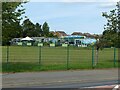
10
Arno Vale Recreation Ground
Open space alongside Arno Vale Road.
Image: © Alan Murray-Rust
Taken: 12 Aug 2021
0.23 miles