IMAGES TAKEN NEAR TO
Grange Road, NOTTINGHAM, NG5 4FW
Introduction
This page details the photographs taken nearby to Grange Road, NG5 4FW by members of the Geograph project.
The Geograph project started in 2005 with the aim of publishing, organising and preserving representative images for every square kilometre of Great Britain, Ireland and the Isle of Man.

There are currently over 7.5m images from over14,400 individuals and you can help contribute to the project by visiting https://www.geograph.org.uk
Image Map
Images are licensed for reuse under creativecommons.org/licenses/by-sa/2.0
Notes
- Clicking on the map will re-center to the selected point.
- The higher the marker number, the further away the image location is from the centre of the postcode.
Image Listing (27 Images Found)
Images are licensed for reuse under creativecommons.org/licenses/by-sa/2.0
Image
Details
Distance
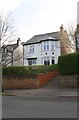
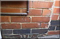
2
Nos. 44 and 44A Grange Road at Tennyson Road junction
Ordnance Survey documents indicate that in 1962 there was a cut mark benchmark at 69.020m above Newlyn Datum at the junction of the two properties which are now rendered. See www.bench-marks.org.uk/bm44368
Image: © Luke Shaw
Taken: 1 Apr 2019
0.11 miles
3
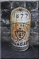
1877 Borough of Nottingham boundary marker, Woodthorpe Drive
This marker has Milestone Society National ID NT_NOT32pb
Image: © Roger Templeman
Taken: 1 Apr 2019
0.12 miles
4
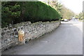
View along Woodthorpe Drive
There is an 1877 Borough of Nottingham boundary marker Image against the wall near the left hand edge of the image
Image: © Roger Templeman
Taken: 1 Apr 2019
0.13 miles
5
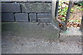
Benchmark on southern parapet of Woodthorpe Drive bridge
Ordnance Survey cut mark benchmark described on the Bench Mark Database at www.bench-marks.org.uk/bm43842
Image: © Luke Shaw
Taken: 1 Apr 2019
0.17 miles
6
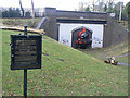
Train Sculpture
An amusing representation of a steam locomotive emerging from a bridge, within a bridge. This was a genuine railway bridge, where the Nottingham Suburban Railway (see information board left - Image ) passed under Woodthorpe Drive.
Image: © Alan Murray-Rust
Taken: 8 Mar 2009
0.18 miles
7
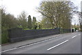
Bridge taking Woodthorpe Drive over dismantled railway
There is an Ordnance Survey benchmark Image on the far end (road face) of the bridge parapet
Image: © Luke Shaw
Taken: 1 Apr 2019
0.18 miles
8

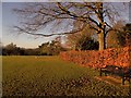
Woodthorpe Grange Park
Old tree in the formal gardens
Image: © norman griffin
Taken: 7 Jan 2018
0.18 miles
9
Nottingham Woodthorpe
Woodthorpe Grange Park
Image: © norman griffin
Taken: 7 Jan 2018
0.19 miles
10
Benchmark on No. 65 Woodthorpe Drive
Ordnance Survey cut mark benchmark described on the Bench Mark Database at www.bench-marks.org.uk/bm44365
Image: © Luke Shaw
Taken: 1 Apr 2019
0.20 miles