IMAGES TAKEN NEAR TO
Crich View, NOTTINGHAM, NG5 4BS
Introduction
This page details the photographs taken nearby to Crich View, NG5 4BS by members of the Geograph project.
The Geograph project started in 2005 with the aim of publishing, organising and preserving representative images for every square kilometre of Great Britain, Ireland and the Isle of Man.

There are currently over 7.5m images from over14,400 individuals and you can help contribute to the project by visiting https://www.geograph.org.uk
Image Map
Images are licensed for reuse under creativecommons.org/licenses/by-sa/2.0
Notes
- Clicking on the map will re-center to the selected point.
- The higher the marker number, the further away the image location is from the centre of the postcode.
Image Listing (88 Images Found)
Images are licensed for reuse under creativecommons.org/licenses/by-sa/2.0
Image
Details
Distance
1
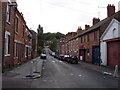
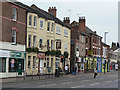
Nottingham - Sherwood NG5
A view of the lower section of a path that forms a short cut between Crich View and Mansfield Street. This very steep, ramp-like path can prove quite challenging for pedestrians during icy or snowy weather.
Having crossed Mansfield Street (on the other side of the posts and railings) Spondon St lies directly ahead with the A60 (Mansfield Rd) at its foot. The top floor of the rear of Sherwood library is visible - it is the light-pink coloured block in the lower left part of the picture.
Image: © David Hallam-Jones
Taken: 16 Mar 2012
0.03 miles
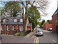
2
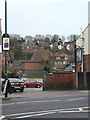
Houses at the back of Sherwood
Ranging from late 19th to late 20th century.
Image: © Alan Murray-Rust
Taken: 15 Mar 2009
0.03 miles
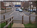
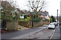
3
Spondon Street, Sherwood
A mixture of housing styles in Sherwood off Mansfield Road.
Image: © Alan Murray-Rust
Taken: 15 Mar 2009
0.04 miles
4
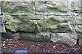
Benchmark on wall on south side of Mapperley Street
Ordnance Survey cut mark benchmark levelled at 80.059m above Newlyn Datum and verified in 1962
Image: © Luke Shaw
Taken: 24 Apr 2020
0.05 miles
5
Nottingham - NG5 (Sherwood)
If only walls could speak. This former Men's Institute on Mansfield Street is now a block of 3-4 apartments. The foundation stone in the entrance porch declares that it "was laid on 29 October 1908 by Mr. Councillor A.J. Butler on land given by Mr L.B. Wilkinson". Who were these gentlemen, one wonders ?
Image: © David Hallam-Jones
Taken: 12 May 2012
0.06 miles
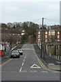
6
Looking west along Mapperley Street
There is an Ordnance Survey benchmark Image on the wall corner on the far side of the entrance drive on the left hand side of the street
Image: © Luke Shaw
Taken: 24 Apr 2020
0.06 miles
7
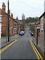
Marshall Street
Part of the Victorian development of Sherwood off Mansfield Road.
Image: © Alan Murray-Rust
Taken: 15 Mar 2009
0.07 miles
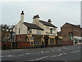
8
The Robin Hood
One of three traditional pubs close together in Sherwood on the east side of Mansfield Road. The others are Image and Image
Image: © Alan Murray-Rust
Taken: 15 Mar 2009
0.08 miles
9
The Sherwood Inn
One of three traditional pubs close together in Sherwood on the east side of Mansfield Road. The others are Image and Image
Image: © Alan Murray-Rust
Taken: 15 Mar 2009
0.08 miles