IMAGES TAKEN NEAR TO
Derwent Terrace, NOTTINGHAM, NG5 4AE
Introduction
This page details the photographs taken nearby to Derwent Terrace, NG5 4AE by members of the Geograph project.
The Geograph project started in 2005 with the aim of publishing, organising and preserving representative images for every square kilometre of Great Britain, Ireland and the Isle of Man.

There are currently over 7.5m images from over14,400 individuals and you can help contribute to the project by visiting https://www.geograph.org.uk
Image Map
Images are licensed for reuse under creativecommons.org/licenses/by-sa/2.0
Notes
- Clicking on the map will re-center to the selected point.
- The higher the marker number, the further away the image location is from the centre of the postcode.
Image Listing (106 Images Found)
Images are licensed for reuse under creativecommons.org/licenses/by-sa/2.0
Image
Details
Distance
1
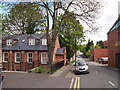
Nottingham - NG5 (Sherwood)
If only walls could speak. This former Men's Institute on Mansfield Street is now a block of 3-4 apartments. The foundation stone in the entrance porch declares that it "was laid on 29 October 1908 by Mr. Councillor A.J. Butler on land given by Mr L.B. Wilkinson". Who were these gentlemen, one wonders ?
Image: © David Hallam-Jones
Taken: 12 May 2012
0.02 miles
2
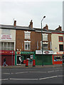
Sherwood Post Office
Small unit in an early 19th century building, serving an important suburban shopping centre. Note the paired pillar boxes outside.
Image: © Alan Murray-Rust
Taken: 15 Mar 2009
0.03 miles
3
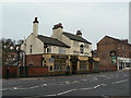
The Sherwood Inn
One of three traditional pubs close together in Sherwood on the east side of Mansfield Road. The others are Image and Image
Image: © Alan Murray-Rust
Taken: 15 Mar 2009
0.03 miles
4
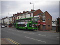
Bus descending Mansfield Road, Sherwood
A 59 to Nottingham city centre passes some of the shops on Mansfield Road in Sherwood district centre.
Image: © Richard Vince
Taken: 3 Sep 2011
0.03 miles
5
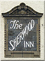
The Sherwood Inn
Fine terracotta sign incorporated into the inn facade.
Image: © Alan Murray-Rust
Taken: 15 Mar 2009
0.03 miles
6
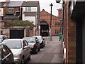
Nottingham - Sherwood NG5
A view of the former Nottingham City Transport Bus Depot on Mansfield Rd (A60) from Marshall St. Prior to being a bus depot it was the local tram depot. The old sheds are now split, 3/4 of them being used as a city council mini-bus depot and the remaining 1/4 as a Wetherspoon's pub. The area at the back of the depot that was once used as offices, rest areas and a cafeteria etc are now used as base for arts & community groups. This recreational area is now called "The Place" and is run by the Sherwood Depot Action Group.
Image: © David Hallam-Jones
Taken: 16 Mar 2012
0.04 miles
7
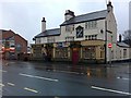
The Sherwood
Or, according to the sign on the main body of the building, The Sherwood Inn.
On Mansfield Road, Sherwood, Nottingham.
Image: © David Lally
Taken: 30 Dec 2009
0.04 miles
8
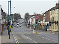
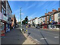
Sherwood Shops
An old-established and still lively local shopping centre on Mansfield Road. The traffic is generally heavier than this, but this was a Sunday afternoon, and i was able to wait until there was a lull.
Image: © Alan Murray-Rust
Taken: 15 Mar 2009
0.04 miles
10
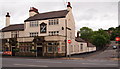
Sherwood, NG5, Nottingham.
The Sherwood Inn at the junction of Lloyd Street with Mansfield Road (the A60).
Image: © David Hallam-Jones
Taken: 13 Jun 2013
0.04 miles