IMAGES TAKEN NEAR TO
Larwood Grove, NOTTINGHAM, NG5 3JD
Introduction
This page details the photographs taken nearby to Larwood Grove, NG5 3JD by members of the Geograph project.
The Geograph project started in 2005 with the aim of publishing, organising and preserving representative images for every square kilometre of Great Britain, Ireland and the Isle of Man.

There are currently over 7.5m images from over14,400 individuals and you can help contribute to the project by visiting https://www.geograph.org.uk
Image Map
Images are licensed for reuse under creativecommons.org/licenses/by-sa/2.0
Notes
- Clicking on the map will re-center to the selected point.
- The higher the marker number, the further away the image location is from the centre of the postcode.
Image Listing (68 Images Found)
Images are licensed for reuse under creativecommons.org/licenses/by-sa/2.0
Image
Details
Distance
1
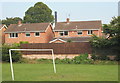
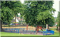
Day Brook Recreation Ground, Nottingham NG5
Houses on Larwood Grove with the main City Hospital chimney stack behind them. Inside the park is a goal post that looks as though it has been swung on by a number of people at the same time.
Image: © David Hallam-Jones
Taken: 12 Jul 2014
0.03 miles
2
Valley Park Ford
This new ford on the Day Brook was identified by Alan Murray-Rust in his photograph:
https://www.geograph.org.uk/photo/7075987
Image: © John Walton
Taken: 27 Nov 2022
0.04 miles
3
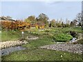
Flood alleviation of the Day Brook in Valley Park ? 7
The lower end of the new course of the stream. The old course exits from the grated conduit, which will have flow during flood periods and may also have some connected surface water drains.
Image: © Alan Murray-Rust
Taken: 18 Jan 2022
0.04 miles
4

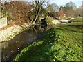
Flood alleviation of the Day Brook in Valley Park ? 6
Ford on the new course, allowing vehicle access to the old course for maintenance purposes. The notice states that the public are not allowed to use the ford!
The construction of the ford is unusual, being created from coarse stones allowing the water to percolate through.
Image: © Alan Murray-Rust
Taken: 18 Jan 2022
0.04 miles
5
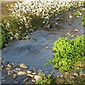
Flood alleviation of the Day Brook in Valley Park ? 5
Part of the new course showing the stone bed and some of the developing vegetation. The bright green plant is watercress, which would be native to a stream like this, but has probably been planted rather than self-seeded.
Image: © Alan Murray-Rust
Taken: 18 Jan 2022
0.05 miles
6
Day Brook Recreation Ground, Nottingham NG5
A 'fairly elderly' children's playground near the Five Ways Hotel end of this park. In early August a budget of £50,000 was approved for the development of a new children's playground near to Hucknall Rd/City Hospital roundabout. As a result, this playground will be dismantled in due course and the area turfed over. The cars seen here are travelling along Valley Road (the A6514) towards the Five Ways Hotel, a public house.
Image: © David Hallam-Jones
Taken: 12 Jul 2014
0.05 miles
7
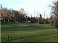
Valley Road Recreation Ground
Strictly knockabout football only - the space is too small for a formal football pitch.
Image: © Alan Murray-Rust
Taken: 8 Mar 2009
0.06 miles
8

The Day Brook in Valley Road Park
The watercress has expanded considerably since January https://www.geograph.org.uk/photo/7075990 .
Image: © Alan Murray-Rust
Taken: 2 Dec 2022
0.06 miles
9
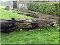
Fallen giant
This tree stump has fallen since I photographed it in January https://www.geograph.org.uk/photo/7075974
Image: © Alan Murray-Rust
Taken: 2 Dec 2022
0.06 miles
10
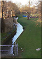
Day Brook at 5 Ways
This stream has been heavily managed as a result of urban development.
Image: © Alan Murray-Rust
Taken: 8 Mar 2009
0.06 miles